Flooding, power outages in New York, New Jersey amid heavy rain Friday. Here's the forecast.
Coastal flood advisories are in effect as a powerful storm system hits New York City, Long Island and New Jersey on Friday.
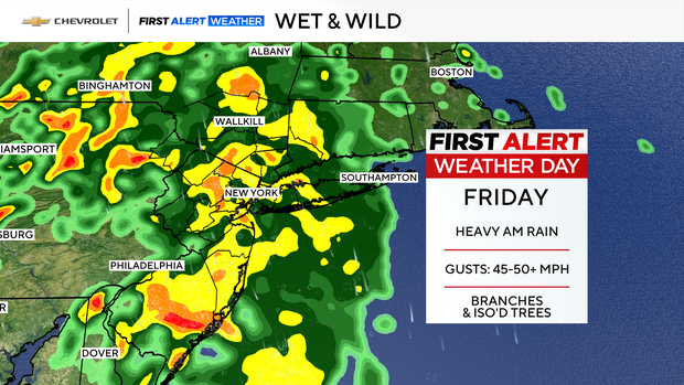
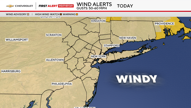
The CBS News New York team declared today a First Alert Weather Day for heavy rain and wind gusts possibly reaching 50 to 60 mph, which are causing downed trees and power outages, in addition to flooding.
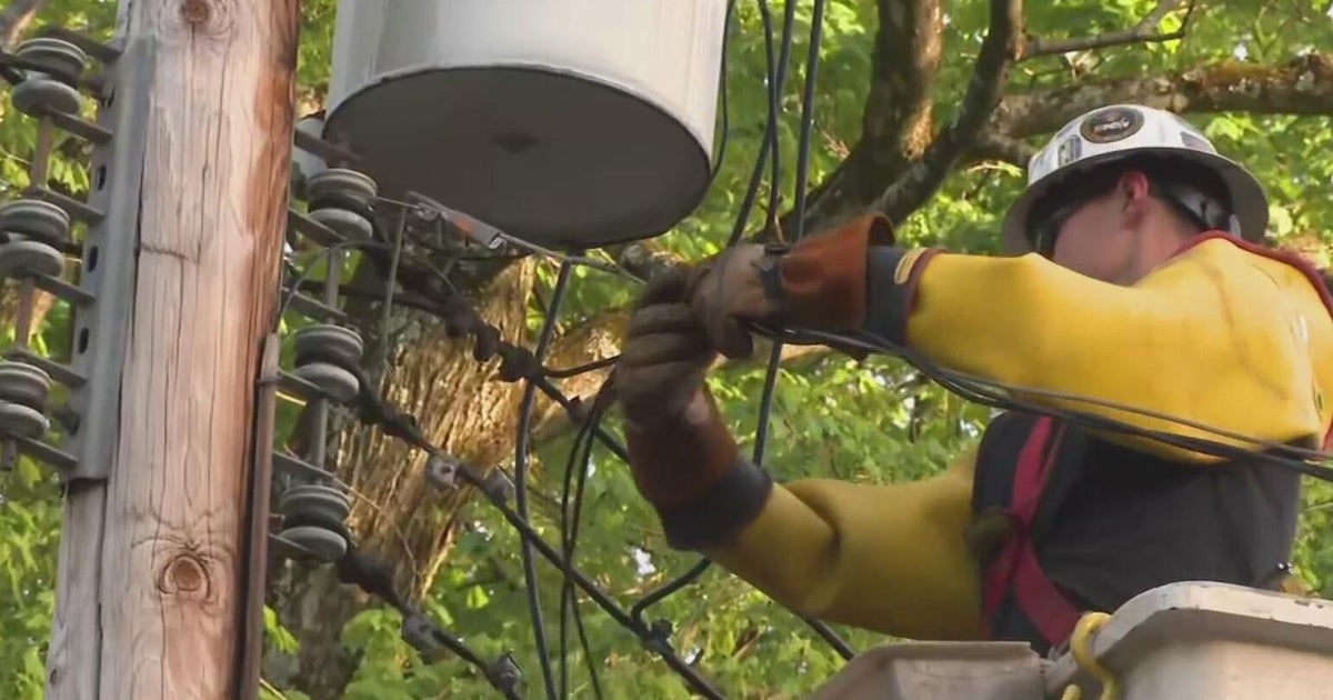
As of noon, more than 18,000 power outages were reported on Long Island, with another 18,000 in New Jersey. Approximately 2,500 outages were reported in the New York City area and northern suburbs.
A severe thunderstorm warning has been issued for Orange, Rockland, Putnam, Westchester, Fairfield, Nassau and Suffolk counties, along with the Bronx, Brooklyn and Queens until 5 p.m. CLICK HERE for the latest warnings, watches and alerts.
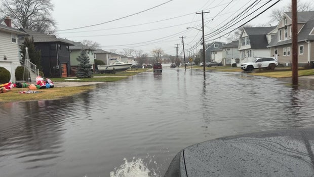
Throughout the region, rain has been coming in waves, picking up in intensity as the day goes on and upping the risk of hydroplaning. Roads near the coast could become impassable during high tide, especially near Long Island's southern shore.
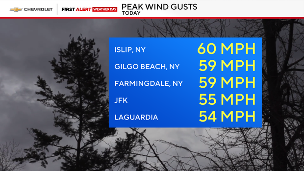
Peak wind gusts
Wind gusts in the Tri-State Area have reached 60 mph in Islip, 59 mph at Gilgo Beach, 59 mph in Farmingdale, 55 mph at John F. Kennedy International Airport, and 54 mph at LaGuardia Airport.
Winds whipped all morning on Long Island as the Great South Bay churned and tossed boats around. Power lines came down at a busy intersection off the Meadowbrook Parkway — on Old Country Road in Carle Place — and was closed to traffic so crews could work on repairs. Side streets flooded in Freeport and ocean waters flooded a parking field at Jones Beach.
"If you don't have to drive today, don't drive. We're having rain with gusts of wind up to 50 mph. It's going to pass over. It'll be over in a few hours, but the roads are ponding. It's going to freeze tonight. Be careful going out there, there's trees down. Make sure before you go out that you let someone know that you're leaving and where you're going to," Suffolk County Executive Ed Romaine said.
MTA Bridges and Tunnels announced that empty tractor-trailers and tandem trucks were banned at all bridges between 5 a.m. and 10 a.m. due to the high wind gusts.
Wild weather ride today
The National Weather Service said coastal flood advisories are in effect Friday, impacting parts of Manhattan, Brooklyn, Queens, Staten Island, Long Island's southern shore and northern New Jersey.
A wind advisory is in effect for the entire area.
Up to a foot of inundation is expected in vulnerable areas on Long Island and in Queens from 4 a.m. to 11 a.m. Friday, according to the NWS. Up to half a foot of inundation is expected in Manhattan, Brooklyn, Staten Island, Hudson, Essex and Union counties from 5 a.m. to 1 p.m., the NWS says.
Some roads and other low-lying properties, like parking lots, parks, lawns and basements, will likely be dealing with minor flooding, officials say.
Drivers are advised to allow extra time for travel when flood advisories are in effect and to not drive around barricades or through any flooded roadways.
Unusually warm
Temperatures will be unusually warm to start Friday, climbing into the 50s during the morning commute. Record-high temperatures in the 50s and 60s are even possible.

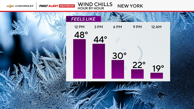
Don't let the warm air fool you. Cold air will rush back in by evening, with wind chills tumbling into the 30s, 20s and even teens.
The bottom line: Secure those holiday decorations, plan for a messy morning commute, and brace for a big temperature drop by Friday evening.
Looking ahead
Here's a breakdown of the forecast:
- Friday morning: Heavy rain and gusty winds -- locally damaging winds possible
- Friday afternoon: Showers exit, but still blustery and much colder
- Friday evening: Leftover rain, or even snow, north and west of NYC; temperatures fall into the 40s, but feel much colder
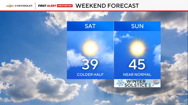
- Saturday: Stays chills with highs in the upper 30s
- Sunday: Rebounds to near-normal temperatures in the mid-40s
Click here for the latest forecast from the First Alert Weather team.