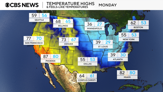
Maps show cold temperatures in eastern U.S., early season lake effect snow due to polar vortex
A harsh drop in temperatures is being delivered to the eastern two thirds of the country thanks to a polar vortex dipping down from the Arctic.
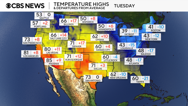
Record cold high temperatures on Monday and Tuesday are expected throughout the South and Southeast along the Gulf Coast states.
Heavy lake effect snowfall
The cold mixed with a low pressure system moving through the Northeast is transitioning precipitation into snowfall in Michigan, Wisconsin, Illinois, Indiana, Ohio, Pennsylvania and New York. Water temperatures in the Great Lakes are currently ranging from 40 to 50 degrees, which is relatively warmer than the cold air above it. The "warmer" waters are helping to enhance the moisture moving over them and causing the increased snow totals downwind of the lakes.
Chicago issued its first Winter Storm Warning for the Chicago metro area since Jan. 12, 2024. That is over 600 days since the last time the winter weather conditions in Chicago metro warranted a Winter Storm Warning.
As of 9 a.m. on Monday, the Chicago metro area saw only 3.5 inches of snow while Chicago Midway International Airport picked up 2.5 inches. The highest snowfall totals so far were seen in northwest Indiana with over a foot measured in some areas.
The Great Lakes will continue to see winter weather conditions and snowfall piling up through Tuesday and Wednesday.

Polar vortex delivering chilly conditions
The polar vortex usually sits over the Arctic but due to normal fluctuations with any weather phenomena, it will sink down into lower latitudes, which is what much of the U.S. is seeing to start the week. It will shift back toward the pole after Wednesday.

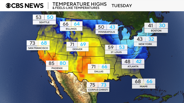
More than 90 million people were under Freeze Alerts from Texas to the Carolinas Monday morning. The alerts will slowly expire as the cold shifts eastward. Wind chills are forecast to be as low as the teens and are expected with sub-freezing overnight temperatures in the 20s and 30s. Temperatures are forecast to be 25-30 degrees below average for this time of year through Wednesday.