Round 1 of snow brings 2-5 inches to central Minnesota; next round could leave a foot or more


MINNEAPOLIS — A winter weather advisory has expired for much of Minnesota Friday after the first round of March snow left several inches in central Minnesota. But the next round could leave much more in its wake.
WEATHER RESOURCES: More weather coverage | Animated radars | School Closings & Delays
Many snow reports show 2-5 inches of snow fell across Minnesota, specifically in central Minnesota, including the Twin Cities. Friday's forecast high is 33 degrees. As the system clears out, there is some potential for sunshine.
The weekend will start quiet with sunshine and temps in the lower 30s. Some flurries are possible late Saturday before the next storm system approaches Sunday.
RELATED: Major weather shift could make March the snowiest month of the season in Minnesota
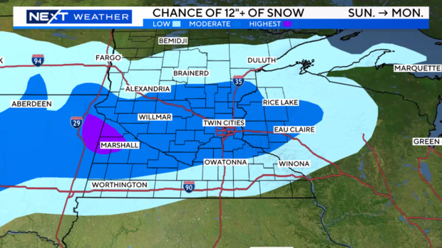
Current models indicate that central Minnesota, including the Twin Cities, could see a foot or more of accumulation between Sunday and Monday.
NEXT Drive: Overnight snow to make for tough Friday morning commute in the Twin Cities
Tuesday looks to be wet and potentially a little snowy as well. This system will likely clear on Wednesday, and temps will warm on Thursday.
It's possible this multi-day storm could be one of the 20 heaviest in the Twin Cities on record when all is said and done on Tuesday.


