NEXT Weather: Thursday's storm may put this winter into list of top 10 snowiest
MINNEAPOLIS – We're currently in the 12th snowiest winter on record, but we may crack the top 10 as soon as Thursday.
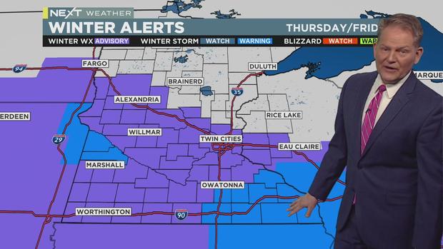
Thursday and Friday will both be NEXT Weather Alert days due to heavy, wet snowfall.
The Twin Cities up through the Moorhead area are under a Winter Weather Advisory, with 2-4 inches of accumulation expected by Friday evening.
A Winter Storm Warning is in effect for the state's southeast corner, as well as a pocket near the Minnesota River in western Minnesota. These areas will likely see 5-plus inches of accumulation by Friday evening.
Light flurries may be falling during the Thursday morning commute. The steadier bands of snow will arrive in time for the evening commute. Expect a slushy accumulation because of the mild temperatures. Winds will also start to pick up from the east, with speeds between 10-15 mph.
The snow will thin after midnight, and the system should clear out by the Friday morning commute.
We'll get a little break before a classic Alberta clipper system rolls in early Saturday. It will linger into early Sunday evening. Early estimates also put this system's snow total in the 2-4 inch range.


