MN Weather: Snow To Fall Overnight, 'Worst Commute' Expected Friday Morning
WHAT WE KNOW
– Snow to fall across Minnesota late Thursday and into the overnight hours
- Worst commute across the region will be Friday morning
– Strong winds Friday of 40+ mph could lead to visibility issues, especially to the west and north
– Much colder weekend to follow
– More snow possible Saturday into Sunday morning
WHAT WE DON'T KNOW
– How much snow will melt on impact across the state
– How much snow will fall Saturday evening into Sunday
– How long snow will stick around with temps warming next week
WEATHER RESOURCES: WCCO Weather App | School Closings | Live Radar
MINNEAPOLIS (WCCO) -- A storm system swirling over Minnesota on Thursday is bringing the first real taste of winter to parts of northern Minnesota, where snow has been falling across parts of the region since the overnight hours. Yet, as the back end of the system looks to sweep over the state late Thursday, the wintry weather will extend to southern Minnesota, including the Twin Cities.
On Wednesday, the first phase of the storm brought soaking rains across Minnesota before stalling out along the North Shore. This stalled swirl led to a clearing across much of the state Thursday morning. But patchy snow showers in Canada and the Dakotas are expected to consolidate on the back end of the low pressure system and swoop down across Minnesota in the overnight hours.
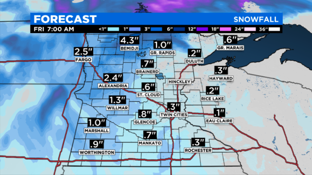
Northern Minnesota could see several inches of snow stack up, particularly on grassy areas. Models show about 3 inches accumulating near International Falls and Bemidji, although it's difficult to know how much of that snowfall will melt on contact with the still-warm ground. Northwestern, west-central and southwestern Minnesota could also see a few inches of snow stack up.
As for the Twin Cities, less than half an inch is expected by Friday morning, according to WCCO-TV Chief Meteorologist Chris Shaffer. The metro will hit the freezing mark by 5 a.m., with the most accumulation occurring around that time. This will be the most challenging time to be on the roads, even if the main roads in the metro are only wet, as temperatures will be above freezing. Secondary roads could be slick.
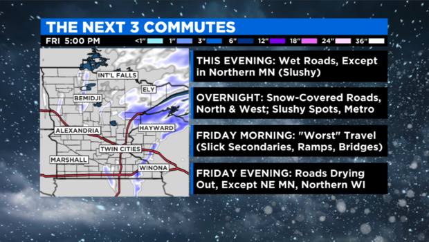
The Worst Commute
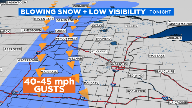
Starting Thursday evening, winds will pick up across Minnesota, lashing some areas will gusts as strong as 55 mph.
The National Weather Service has issued a winter weather advisory for nearly the entire western half of Minnesota. Additionally, a winter storm warning has been issued for north-central Minnesota, and a blizzard warning has been issued for a few counties along the South Dakota border.
The threat posed by these advisories and warnings is more-or-less the same: Strong winds will make the snow fly sideways, greatly reducing visibility and making travel dangerous. In some areas where the snow is falling heaviest, road conditions could rapidly deteriorate.
At least two school districts in the blizzard warning area have canceled in-person classes for Friday. For more school closing information, click here.
While the winds are expected to die down by midday Friday, gust of up to 40 mph are still expected through the afternoon.
Another Snow-Maker This Weekend
On Saturday afternoon, an Alberta clipper system looks to descend on Minnesota, covering a swath of the state with another coating of fresh snow.
Depending on where the snow band sets up, communities could see between 1 and 3 inches of snow. Currently, models are placing the band north of the Interstate 94 corridor, which would mean the system might only clip the Twin Cities metro.
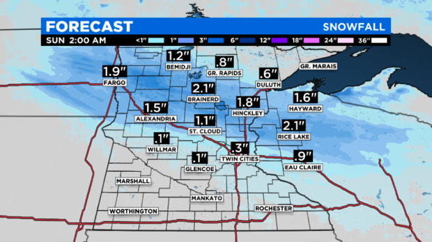
However, the storm could yet track further south, perhaps bringing higher accumulations to the metro. On average, the Twin Cities sees its first one-inch of snowfall around Nov. 16.
Meanwhile, weekend temperatures will be the coldest Minnesotans have experienced so far this season. Daytime temperatures won't rise much higher than the mid-30s, and overnight lows will be in the 20s.
Melting Next Week?
Although the weekend will be chilly, temperatures will bounce back Tuesday, when highs are expected to above average. This means whatever snow falls in the Twin Cities (or other parts of the state) will almost certainly melt, as even overnight temperatures will be above freezing.
Additionally, sunshine looks to be in store for Tuesday and Wednesday.


