How much snow will Minnesota get on Sunday? Here's what we know


MINNEAPOLIS — A major storm is making its way through Minnesota, and by the time it wraps up, much of the state will see half a foot of snow or more.
MONDAY'S UPDATE: A look at snow totals for Minneapolis, across the state
A winter storm warning will be in effect for the Twin Cities through 4 a.m. Monday. Much of the rest of the state will be under a similar warning. Sunday through Tuesday will be NEXT Weather Alert days.
Greatest snowstorm impacts
The heaviest rounds will fall through the evening Sunday. There will be widespread travel issues after 8 p.m., NEXT Weather Meteorologists say.
At times, the snowfall rates could reach 1-to-2 inches per hour, with gusts up to 40 mph. The snow will be heavy and wet, making it difficult to shovel.
At 7 p.m., the National Weather Service says it measured three inches of snow at MSP Airport.
MORE: Minnesotans are preparing physically and financially for the big weekend snowfall
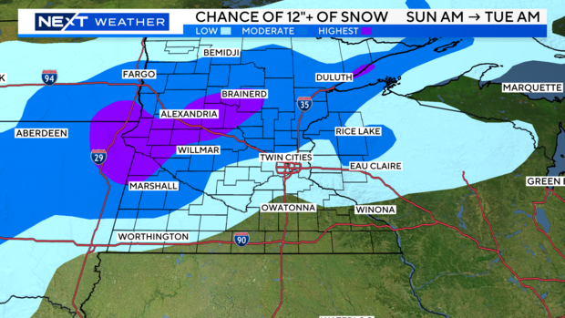
By midnight Sunday, NEXT Weather Meteorologists say that the metro area could see between 6 and 10 inches of snow. Areas to the north and west — like Marshall, Alexandria and Brainerd — could see more than a foot. The North Shore will be under a blizzard warning.
Some warm air will move in along Interstate 90 from Sunday into Monday, which will turn the snow into rain. That rain could cut back on some of the snow totals in the southeast. The warm nose of air isn't expected to hit the northern and western parts of the state however, meaning that snow totals there could continue to climb into Monday evening.
The timing and movement of the warm air is still uncertain, so it's difficult to determine where and when, precisely, the snow will turn into rain.
The rain will change back into snow Monday night and taper off through Tuesday.
A high pressure system returns Wednesday, making for much calmer weather on Wednesday through Friday.
Travel impacts
If you need to get out of the house on Sunday, it's best to do it as soon as possible.
"One of the greatest impacts from this storm is going to be with travel, given the fact that we're going to have the snow and the wind," NEXT Weather Meteorologist Adam Del Rosso said. "And those impacts are only going to grow as we head into the afternoon and evening."
Travel impact from the storm will be moderate through the afternoon and early evening in the Twin Cities. Starting around 8 p.m., impact will be high.
Minnesota Department of Transportation spokesperson Anne Meyer said about 800 snowplows are at the ready statewide, 200 of them in the metro. There are twice as many drivers to keep the plows going day and night.
"Already hard at work out there, a lot of crews already taking and dealing with the amount of snow we're seeing so far," Meyer said. "We're going to see a lot happening out there, it's changing by the hour and we want drivers to be ready for those changes as well."
As of 8:30 p.m. Sunday, there were 36 active crashes around the metro, according to MnDOT.


