Severe Thunderstorm Warning issued for northern Miami-Dade County

Severe thunderstorms developed in the early evening across South Florida on Thursday evening.
Severe Thunderstorm Warning
The National Weather Service issued a Severe Thunderstorm Warning for northern Miami-Dade County until 8:15 p.m.
At 7:45 p.m., a severe storm was located over Sweetwater, near South Miami, and was moving southeast at 15 mph. The storm is bringing wind gusts up to 60 mph and quarter-sized hail.
Radar indicated the storm, which is expected to cause hail damage to vehicles and wind damage to roofs, siding, and trees.
Impacted areas include Miami, Hialeah, Coral Gables, Kendall, Doral, Sweetwater and Miami International Airport, among others.
Residents were urged to move to an interior room on the lowest floor of a building.
The National Weather Service said torrential rainfall could cause flash flooding and drivers were warned not to travel through flooded roads.
NEXT Weather Alert Days
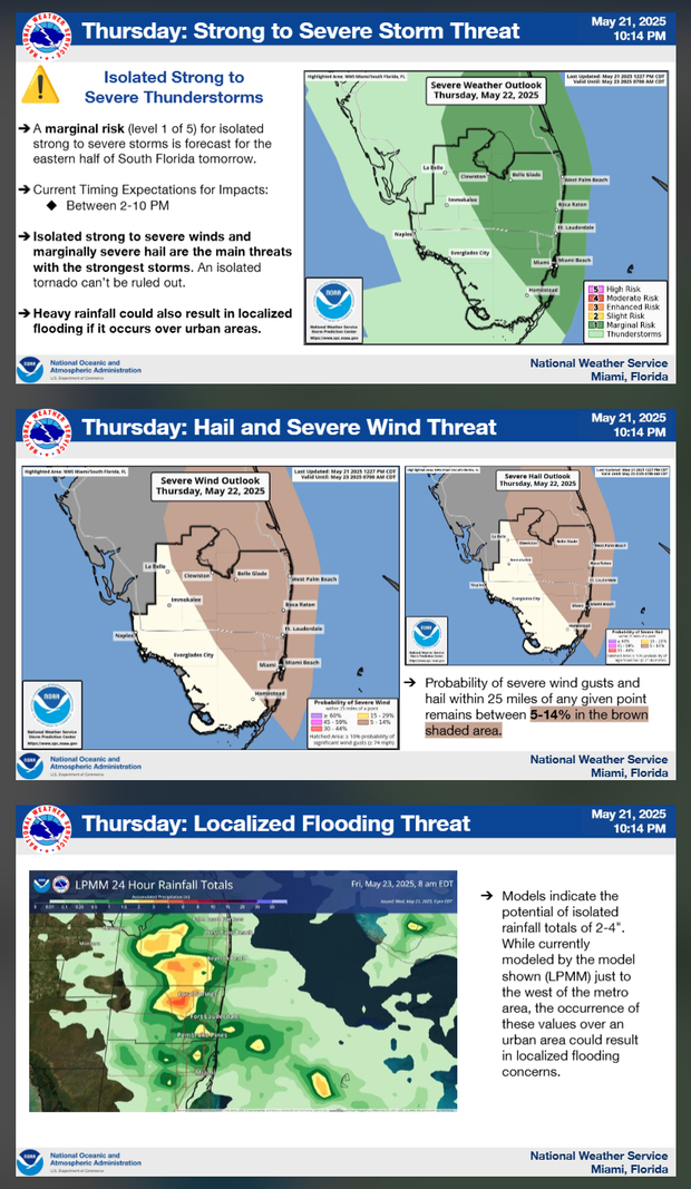
The NEXT Weather Team had issued NEXT Weather Alert Days for both Thursday and Friday due to the potential for strong to severe afternoon storms.
The main concern will be storms which could contain damaging wind, hail, and isolated heavy downpours.
NEXT Weather Chief Meteorologist Ivan Cabrera said a frontal boundary will get an atmospheric kick and push toward the southeast across Florida on Thursday.
A pocket of deeper atmospheric moisture will move in with the front and bring showers and storms back into the picture. A southwesterly flow, along with a pinned sea breeze, will act to focus showers and storms along the coastal metros.
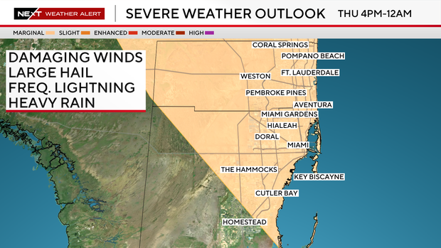
The Storm Prediction Center has Broward County and the Miami-Dade metro area at a marginal risk for isolated strong storms on Thursday and Friday afternoons.
The storms will form primarily in the afternoon and early evening hours. While the risk level is marginal, the lowest on the SPC's five-tier scale, residents are urged to stay weather-aware, especially during peak storm times.
Outdoor plans and commutes could be impacted by sudden downpours or localized severe conditions.
In addition to storms, Thursday will be another hot day with temperatures in the lower to mid-90s and "feels like" temperatures in the triple digits.
The heat continues through Memorial Day Weekend with afternoon highs in the low 90s, and "feels like" temperatures in the mid to upper 90s. The chance of rain is 30% for scattered showers.