Flooding threat increases as rounds of rain, scattered storms hit South Florida
Rinse and repeat. A system bringing heavy downpours and storms prompted the flood risk level to rise across South Florida Tuesday.
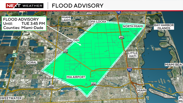
The Weather Prediction Center has placed Broward and most of Miami-Dade under a level 2 risk of flash flooding as storms developed around midday. Storms have an initial burst of heavy rain and then taper off, which will allow the flooded roadways to clear.
Highs climbed to the low 90s Tuesday afternoon, with feel-like temperatures in the 100s before the rain began rolling in to bring some relief. More showers and storms are possible throughout late Tuesday afternoon and evening, but they will have a difficult time holding together as they move into rain-cooled air.
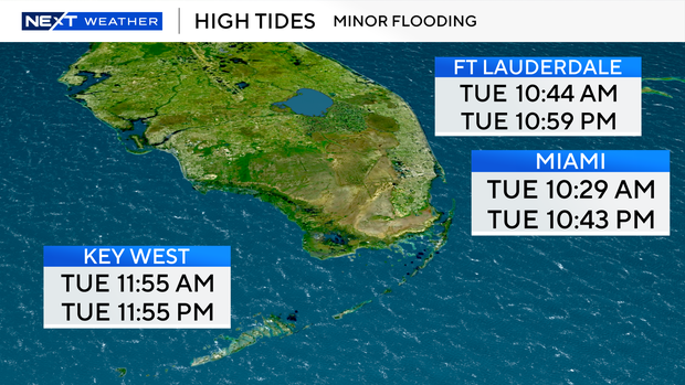
In addition to the threat of flooding from the storms, minor saltwater flooding will be possible around high tide times due to the higher-than-normal king tides. The next high tides in Ft Lauderdale will occur at 10:59 p.m. The next high tides in Miami will occur at 10:43 p.m. The next high tides in Key West will occur at 11:55 p.m.
There is a low risk of rip currents along the Atlantic beaches. There are no alerts or advisories for boaters along the Atlantic waters and the Keys waters.
The chance of rain remains high Wednesday. Plenty of moisture will lead to scattered to numerous storms in the afternoon and evening.
The flood threat continues through late week with the potential for scattered storms every day that could produce heavy rain and localized flooding.
This weekend, the chance of rain will decrease a bit, and it will not be as hot due to an onshore breeze developing. Highs will be in the upper 80s on Saturday and Sunday.


