South Florida cold front brings drier air, chilly morning temps

A wet start across parts of South Florida as scattered showers and storms move in due to a cold front on the way.
Monday morning got off to a mild and muggy start with temperatures in the upper 70s. The afternoon will be drier and breezy. As winds increase out of the northwest at 10 to 15 miles per hour, gusts could reach 30 mph. A red flag warning has been issued from noon through 7 p.m. due to the combination of the strong winds, lower humidity of 25% or less and warm weather that contributes to a high fire danger.
There is a high risk of rip currents along the Atlantic beaches. A small craft advisory has been issued for the Atlantic waters and Keys waters due to increasing winds and hazardous marine conditions.
Brief return to chilly morning weather
Once the front clears, temperatures will fall to the 50s overnight. Some inland areas may drop to the upper 40s.
It will be a chilly start on Tuesday morning and feeling like winter again South Florida style. Layers needed in the morning but it will be pleasant and breezy in the afternoon with highs in the upper 70s with plenty of sunshine.
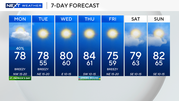
We gradually warm up midweek. Although it will be cool with low 60s on Wednesday morning, highs will then bounce back to around 80 degrees. It will be even warmer on Thursday as highs climb to the low to mid 80s ahead of our next cold front.
Temperatures will dip once again by Friday morning into the upper 50s. Highs in the mid 70s by Friday afternoon.
Warmer this weekend with highs near 80 degrees Saturday and the low 80s Sunday.