Mudslide threats linger after rain moves out of Southern California
The sunshine returns after several days of steady rain prompted flooding concerns and one evacuation in Southern California.
Authorities are continuing to urge caution on area roads due to the saturated soil, increasing the possibility of mudslides.
As of Thursday morning, two southbound and one northbound lanes on Pacific Coast Highway between Latigo Canyon and Corral Canyon have reopened after rockslides, according to Caltrans.
Malibu Canyon Road remains closed in both directions at Piuma Road due to a large mudslide. California Highway Patrol officials said the road was expected to remain blocked for an undetermined amount of time.
The issues forced Pepperdine University to cancel all in-person classes Wednesday at its Malibu campus.
SMMUSD schools in Malibu remained closed on Thursday.
Farther north, a large rock fell on Bouquet Canyon Road near Texas Canyon Road in Santa Clarita. Meanwhile, overnight rain led to flooding on the Glenn Anderson (105) Freeway in Lynwood near Alameda Street, leaving one car disabled.
A mudslide also closed a 12-mile stretch of SR-150 in both directions in Santa Paula as Caltrans crews work to cleanup the debris. Caltrans expects the removal of the mudslide to take weeks, not days, due to the volume of the slide and the damage it caused.
"The slide continues to slide onto the roadway; therefore, removing it from the bottom won't achieve much since more will fall," according to County of Ventura officials.
As of Wednesday morning, more than 5 inches of rain had fallen in the Bel Air area over the past five days, while 4 inches fell in Beverly Hills and more than 2 inches in Culver City. Nearly 5 inches fell in Porter Ranch, while 3 inches fell in Pasadena, and 2.6 inches were recorded in Newhall. More than 8 inches were recorded in parts of the Santa Monica Mountains.
"Rapid rises in small streams and urban roadway flooding is likely during periods of heavier rainfall. Debris flows, mudslides, landslides, and swift water rescues could happen just about anywhere within the flood watch area," according to the National Weather Service.
RELATED: List of Los Angeles parks closed due to rain
Although the system didn't pack the same punch as the area's recent record-setting downpours, flood concerns heightened due to the soaked terrain, prompting Los Angeles city officials to put comprehensive measures in place to manage the effects of the winter storm.
City officials put a series of emergency response programs into action ahead of the brunt of the storm, including activation of search and rescue crews and the Los Angeles Homeless Service Authority's Augmented Winter Shelter program to help people get off the streets during the dangerous weather.
"Over the past week, the City has worked to repair more than 4,000 potholes, reinforce hills that are at risk of mudslides and prevent power outages by making repairs to underground equipment and vaults that had flooded during the previous storm," Mayor Karen Bass said Sunday on X.
Sepulveda Basin closed for flooding
The Sepulveda Basin, between Burbank and Victory boulevards and Havenhurst and Woodley avenue, will remain closed due to flooding.
Mulholland Drive also remains closed between Skyline Drive and Bowmont Drive due to severe road damage at four locations that occurred during earlier rains. That closure was expected to last weeks, officials said.
Phase 2 debris flow forecast
LA County Public Works officials issued a "phase 2 debris flow forecast" for the Land Fire burn area east of Sun Valley. The alert will be in effect until 9 a.m. Wednesday, according to the Los Angeles Fire Department, which said moderate flooding and mudflow/sediment deposition should be anticipated in the area of McDonald Creek, Del Arroyo Drive and La Tuna Canyon Road.
"If conditions worsen, evacuation orders may be issued and evacuation sites will be identified," the LAFD said. "Take action now to be ready to quickly evacuate if you live on the streets along La Tuna Canyon Road with the borders of Horse Haven Street to the north, Martindale Avenue to the east, Penrose Street to the south, and Ledge Avenue to the west."
Farther south, a portion of Benedict Canyon Road was restricted to local access only due to a collapsing roadway. The "soft closure" was in effect from Mulholland Drive to Hutton Drive, with Deep Canyon Drive suggested as an alternate route.
Also, a portion of Mulholland Drive remained closed to through traffic between Skyline Drive and Bowmont Drive due to severe road damage at four locations. That closure was expected to last weeks, officials said.
The storm is also expected to produce high surf and gusty winds in the mountains and foothills. Snow levels during the peak of the storm will be about 8,000 feet, lowering to around 7,000 feet Monday or Tuesday, with 5 to 10 inches possible between 6,500 and 8,000 feet.
Residents in Rancho Palos Verdes are quite literally living on the edge, surrounded by an accelerated land movement that has destroyed dozens of homes since mid-2023. They're hopeful that the state government will jump into action and assist them before it's too late.
High surf advisory through Tuesday
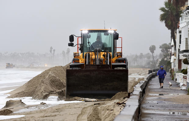
A high surf advisory was issued through Tuesday at all west and southwest facing beaches, with waves up to 10-15 feet expected.
"A very strong 170 mph jet streak and modest lapse rates will support a slight chance of thunderstorms building into the region around the same time frame," the NWS said. "Any thunderstorms or convective showers may support dangerous cloud-to-ground lightning, gusty and damaging winds, and a brief water spout or tornado."
Dry weather with warming temperatures is expected to return Thursday and Friday, before another possible bout of light rain next weekend.
Orange County, Inland Empire getting hit hard
After going without much rain for much of Sunday and Monday, the Orange County and Inland Empire areas were hit hard by rain on Tuesday, beginning at around midnight and continuing through the early afternoon.