Storms Threaten North Texas Overnight/Tomorrow
-MASSIVE TORNADO OUTBREAK IN THE MIDWEST CONTINUES
-STRONG STORMS OVERNIGHT THREAT IN OUR NORTHWEST CORNER
-MORNING STORMS IN THE METRO; SEVERE WEATHER EASTERN COUNTIES MID-DAY ON
We have been watching a massive tornado outbreak continue across north Oklahoma, central Kansas, southern Nebraska and Iowa. There are already over 50 reports of tornadoes and as of this hour the outbreak is still in full force. Current Tornado Watches are in effect until Midnight and 2am. These Watches are of the "Particularly Dangerous Situation" (PDS) kind, powerful tornadoes will continue into the night.
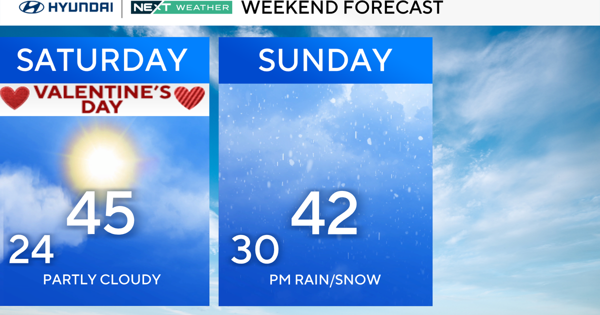
TONIGHT: Storms West, Some severe, Low of 70°, Cloudy with strong south winds 15-25 mph.
TOMORROW: Morning Storms, Some Severe, Winds Turning West, Mid-60s Mid-morning, Upper 70's Afternoon and Clearing.
SUNDAY NIGHT: Cooler and Less Humid, Mostly Clear, Low down to the low 50's
OUR FORECAST: OVERNIGHT
Severe weather is expected to develop later tonight over the Texas Panhandle west of Wichita Falls. These storms will make a run towards us through the overnight hours. These storms could get into our western counties of Stephens, Young, Jack and Montague after midnight and approach the I-35W corridor by daybreak. These storms could produce severe weather in the form of damaging winds and large hail.
Below you see one of the more recent short-term model runs showing the line coming through the metro area soon after daybreak:
TOMORROW MORNING
The approaching cold front will cause storms to form ahead of it through the night. I am expecting these storms to arrive here in the metro area sometime in the 7am-9am hour. The tornado threat will be very low with these storms; if any form they will be weak tornadoes along the leading edge that form and dissipate quickly. The main threat will be damaging winds, large hail and frequent lightning. Timing of this front (coming through the morning hours instead of the afternoon at the peak of daytime heating) means less risk for the metro of significant severe weather.
TOMORROW MID-DAY
The front will clear the metro area by late morning and the storm threat will be over for DFW. Temperatures start at daybreak in the metro in the low 70's but will fall briefly into the mid-60's with the passage of the front. As the line moves to our east and daytime heating starts up these storms are going to fire up along the line and produce more severe weather. Another outbreak of significant storms is expected tomorrow afternoon and evening. However only our eastern edge is threatened by these; Anderson, Henderson, Van Zandt, Rains, Hopkins, Delta and Lamar counties. That threat should be over the late afternoon. For the afternoon in the metro area dry air will be in place with a weaker west wind, highs should reach into the upper 70's.
NICE NEXT WEEK...UNTIL FRIDAY
Monday thru Thursday looks dry and mild with highs in the upper 70's to low-80's by Wednesday and Thursday. Another front plows into us on Friday. We'll keep storm chances at 30% on Friday on a windy day. It should be dry on Saturday with highs in the upper-70's.