Arctic Cold Front Brings Cold Rain To North Texas, Will Drop Temperatures Near Freezing Overnight
NORTH TEXAS (CBSDFW.COM) — A blast of winter weather is spreading across the country today, including here in North Texas.
Thanks to an Arctic cold front, temperatures will be running up to 25° below average, with widespread wet weather in the mix as well. For locations in the Texas Panhandle, that means the threat for accumulating snow between 1" and 2" and the area's first Winter Storm Warning of the season.
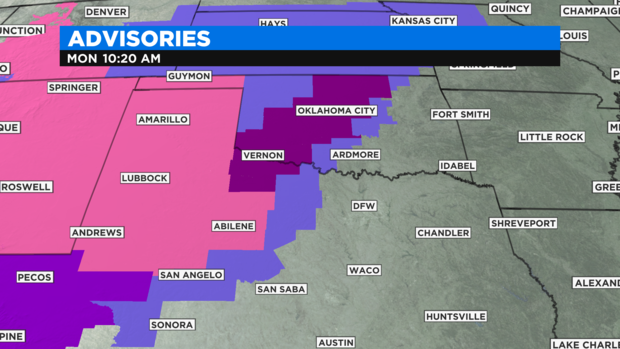
Western and central Oklahoma can expect the system to bring accumulating ice thanks to freezing rain. Oklahoma City is under an Ice Storm Warning, where upwards of a half-inch of ice remain possible.
Here in North Texas, impacts from the front won't be as severe, with mainly rounds of cold rain the next few days and chilly temperatures that are more reminiscent of December or January. Mainly just cold, dreary and damp across DFW.
Overnight Monday, we'll see our coldest temperatures of the season with a range of mid 30s to low 40s from west to east. A few locations -- well west of the Metroplex -- could approach freezing by Tuesday morning, producing a slight threat for freezing rain.
Widespread impacts are unlikely, but a Winter Weather Advisory is in effect for Palo Pinto, Stephens, Jack, Young, and Eastland counties to account for any brief freezing rain.
And for those who aren't ready for the chill... there's good news! Temperatures will warm back up for the weekend, with mild weather in the 60s and lots of sunshine.