Tornado threat expands into parts of Michigan

A tornado watch was issued for Southwest Michigan early Wednesday afternoon, specifically the counties of Berrien, Branch, Cass and St. Joseph where the watch will be in effect into 8 p.m. ET.
June is considered the peak tornado season in Southeast Michigan.
Stay tuned to CBS News Detroit on air and on the livestream for updates.
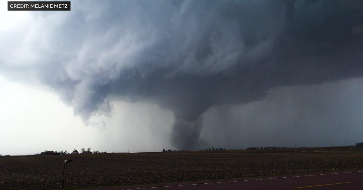
Tornado warning at 1:12 p.m.
In the meantime, a tornado warning was issued for part of Macomb County at 1:12 p.m. The warning was expected to remain in effect until 2 p.m., but was lifted around 1:24 p.m., the National Weather Service reported. The severe thunderstorm, which was capable of producing a tornado, was located over Royal Oak, near Troy, and moving northeast.

"Quick little spinups are possible," CBS News Detroit chief meteorologist Ahmad Bajjey said on his breaking news bulletin.
A temporary "ground stop" was issued for Detroit Metropolitan Airport because of the weather until 2 p.m.
Flooding threat
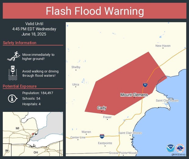
A flash flood warning was issued in part of Macomb County until 4:45 p.m. after that storm cell moved through. There were already waves of heavy rain and storm weather early in the day, including some strong thunderstorms that came through Oakland County in the early afternoon.
The West Bloomfield Township police reported flooding on northbound Orchard Lake at Pontiac Trail.
The Macomb County Road Commission closed Gratiot Ave. from 23 Mile Rd, north to the Home Depot entrance, because of flooding, Chesterfield Township Police Department reported.
The Great Lakes Water Authority, a regional water and sewer network whose district includes much of Metro Detroit, is asking residents of low-lying areas that have been prone to flooding during heavy rainfall "to remain vigilant and out of an abundance of caution, to remove items of value from their basements."
The Michigan State Police, Metro Detroit District, issued this announcement: "Some pretty good storms moving across the district. These quick moving storms are causing ponding on the roadways and freeways. Keep your speeds down, both hands on the wheel and headlights on."
Storm damage
There is storm damage reported in Macomb County just off 14 Mile Road. CBS Detroit is looking into this situation and will have more details as they are available.
Watch vs. warning
The National Weather Service says a severe weather watch means "be prepared." It is possible that weather will reach severe levels during the time frame specified.
A severe weather warning means "take action," that severe weather conditions have been reported by spotters or can be detected on radar. People are asked to take shelter indoors, away from windows.
Tornado weather so far in 2025
2025 is already one of the busiest years for tornadoes in Michigan since modern record-keeping began in 1950.
There were 28 tornadoes confirmed so far, including an outbreak in mid-May.
So far, 1974 holds the top spot with 39 confirmed tornadoes, followed by 2001 with 35 confirmed tornadoes, according to CBS News Detroit's NEXT Weather team.
Power outage reports
Most electricity customers in southeast Michigan get their power from either Consumers Energy or DTE Energy. Both companies have online outage maps where people can look up the status of their neighborhood.
"Our Storm Response Teams are ready to restore power as quickly and safely as possible," a DTE notice posted ahead of the storms said. "Please be safe and remember to stay at least 25 feet from any downed power lines — assume they are live and dangerous. Report any outage or downed line here."
The City of Warren Police Department also issued a reminder to residents to "Please be aware of downed trees and power lines resulting from the storm. If you see a downed power line, move away from it and anything touching it. The ground around power lines – up to 35 feet away – may be energized."