Tornado warnings expire for all Southeast Michigan Thursday


Tornado warnings were issued for most of Southeast Michigan on Thursday, late afternoon and evening, as strong storms moved through the area.
Tornado warnings were issued for Lenawee, Livingston, Macomb, Monroe, Oakland, Washtenaw and Wayne Counties, and all expired by 4:40 p.m. Thursday.
A ground stop is in effect for Detroit Metro Airport in Romulus until at least 4:45 p.m.
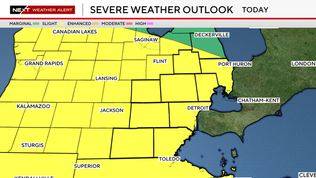
All of Southeast Michigan is under a severe thunderstorm watch for Thursday afternoon and evening, with the risk of strong winds and hail, according to the National Weather Service.
Severe weather alerts
The watch that included Southeast Michigan was issued at 2 p.m. and is expected to remain in effect until 7 p.m. Damaging wind gusts of up to 70 mph and hail up to 1 1/2 inches in diameter are possible.
A severe thunderstorm warning was issued at 2:26 p.m. for Lapeer County.
Earlier on Wednesday
There was a burst of severe weather in Southern Michigan late Thursday morning. This was the second round, and it included a tornado warning issued at 1:47 p.m. for part of Gratiot County in Mid-Michigan. This is all happening even as Metro Detroit residents are cleaning up from severe weather that came through overnight Wednesday into early Thursday, resulting in widespread power outages.
The CBS News Detroit weather team has declared Thursday to be a NEXT Weather Alert Day, stepping up forecasts and announcements as needed.
Did you hear a siren?
Local authorities can activate outdoor sirens in their communities in response to severe weather conditions and other emergencies.
According to local emergency and weather officials, in Sanilac, Lapeer, Livingston, Oakland, and Monroe counties, the sirens are controlled countywide. Sirens in St. Clair, Macomb and Lenawee counties are controlled by specific areas. Washtenaw County is controlled by quadrants, and Wayne County is controlled by different municipalities.
The criteria to do so can vary from one community to the next, but winds of 70 mph or greater are one of the factors they consider.
Outdoor siren locations are also determined on a case-by-case basis.
Watch vs warning
The National Weather Service says a severe weather watch means "be prepared." It is possible that the weather will reach severe levels during the time frame specified.
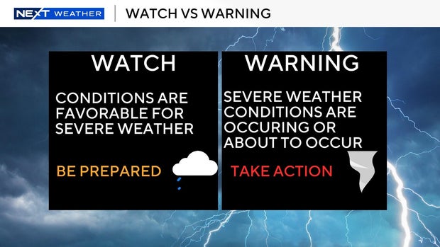
A severe weather warning means "take action" — that is, severe weather conditions have been reported by spotters or detected on radar. People are asked to take shelter indoors, away from windows.
It is possible for a tornado warning to be issued without a tornado watch already in effect. This is the scenario that happened Wednesday night in St. Clair County.
Safe shelter during severe weather
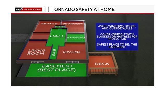
The safest place to go when severe weather threatens is inside a building, on the lower level, and away from windows.
What DTE is doing
DTE said it had been monitoring forecasts and preparing for Wednesday night's weather for several days in advance, scheduling crews and resources before the storms arrived.
Great Lakes Water Authority prepares for rainfall
The Great Lakes Water Authority (GLWA) says it is working to dewater the regional system and maximize available capacity across southeast Michigan.
"All GLWA facilities are in ready mode, and teams are closely monitoring weather forecasts and system conditions throughout the region," said GLWA's Chief Operating Officer of Wastewater Operating Services, Navid Mehram.
According to Mehram, thunderstorms can produce significant rainfall in a short period, which can, in turn, create localized flooding concerns.
"GLWA is prepared to make operational adjustments as conditions develop," Mehram said in the statement. "While system levels remain elevated following Wednesday night's storms, GLWA's regional system performed well, and crews continue working diligently to prepare for additional rainfall."
GLWA is asking residents in low-lying areas prone to flooding during heavy rainfall to remain vigilant and remove valuables from their basements.


