Severe storms, strong winds possible in Southeast Michigan through Wednesday morning

The CBS News Detroit NEXT Weather team is declaring Tuesday and Wednesday NEXT Weather Alert Days.
Strong to possibly severe thunderstorms are expected across Southeast Michigan, beginning Tuesday night. These storms will last overnight and even into Wednesday morning as a powerful storm system moves through the Great Lakes.
Forecast models show a low-pressure system tracking northeast across Lower Michigan, as a warm front stays just south of the state line.
Severe weather timeline
We are watching the storm system to begin intensifying around 9 p.m. to 10 p.m. Tuesday. Rounds of strong thunderstorms will continue while we are sleeping and for our morning commute. Up to 2 inches of rain is possible, a scenario that the Great Lakes Water Authority says it is monitoring.
The last push of the system looks to be around mid-morning on Wednesday before tapering off through the end of the morning. We'll expect drier conditions through Wednesday afternoon.
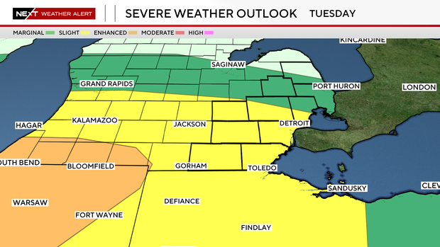
Severe weather risk
Currently, Southeast Michigan is split between a marginal risk (level 1 out of 5) and a slight risk (level 2 out of 5) for severe weather. Areas in southwest Oakland and Macomb counties and south to the state line are under the slight risk category. Areas north of that line are in the marginal risk category.
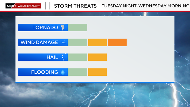
Severe threats for this system include damaging wind gusts up to 60 miles per hour, frequent lightning, heavy rainfall, and around 1-inch hail, with storms capable of producing locally intense downpours, with rainfall totals reaching 0.75–1.75 inches. A few stronger thunderstorms could develop as storms move in from the west, potentially spawning tornadoes in the area.
These storms are forming because warm, moist air surging north from the Gulf of Mexico is colliding with a strong cold front and upper-level storm system moving in from the Plains, creating atmospheric instability. This clash of warm spring-like air with colder air aloft, combined with strong winds in the upper atmosphere, helps storms organize and sometimes become severe.
A similar setup recently produced severe storms and tornadoes in parts of Michigan and the Midwest last week, highlighting how early-season spring patterns can rapidly intensify storms across the region.
The CBS Next Weather Team is always here for you and will continue to track the threat of severe storms as it approaches Tuesday night. Stay safe and stay aware.