Another round of snow expected in Southeast Michigan on Friday

As we dig out from the (admittedly) unexpected amount of snowfall on Wednesday, we are facing yet another round of snow on Friday.
Given the forecast, CBS News Detroit's weather team has declared a NEXT Weather Alert starting at noon Friday and continuing through 7 p.m.
Dare I say, it looks similar to the last round of snow, where one cold front will follow another. Hopefully, unlike Wednesday, this time around the second cold front will follow as it should and not take its good ol' time like the last one, which allowed us to get snow dumped on us.
We have an article explaining why the region saw more snow than expected.
Calm conditions and sunshine give us some much-needed respite before we start seeing flakes fly tomorrow morning. Snow will move in around 5 a.m., with the heaviest of snowfall around noon and the snow beginning to break up during the evening commute.
The morning commute might still be dicey as roads are still being cleared from yesterday's snowfall, and accumulations for Friday's snow will begin immediately. A chance of some light snow showers will continue on Friday night with some lake effect enhancement during the Friday night through Saturday timeframe.
So, how much snow are we going to get? A blanket of 1 to 3 inches of snowfall, with an isolated 4 inches, is possible across the region. Higher-end snowfall will be especially closer to Flint and in higher altitude areas. However, we could receive up to about an inch on Saturday, too. It'll be enough to break the shovel or snowblower back out.
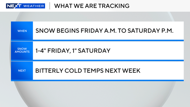
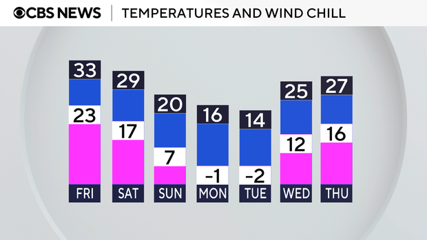
We still have some chances for snow into next week, but what might really make you want to crawl under the covers and set an alarm for "spring" will be the bone-chilling temperatures.
Expect wind chills to be well below zero as we start the work work and temps on Monday and Tuesday won't even feel above zero all day, but that's an article for a different day.
For your latest NEXT Weather forecast, watch on air, online or on the stream with the CBS app or PlutoTV.