First chance of snow this season coming to Southeast Michigan this weekend


Snow finally makes a return to the Southeast Michigan forecast this weekend.
An area of low pressure swings through the region and will bring cold enough air with it to allow a change from rain to snow late Saturday night.
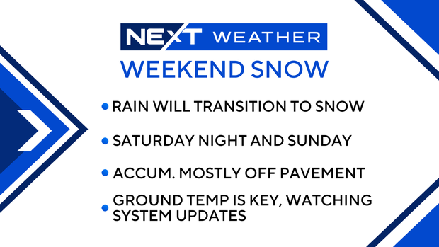
Our ground temperatures are quite warm, near 50 degrees in some spots, so any snow that falls will have to contend with this to accumulate. Rain will arrive slowly after 10 p.m. Saturday, with a chance of snowfall possible through the night.
Our best snow chance is Sunday morning as colder air wraps around the system.
Expectations right now are for no accumulation, or minor on the grass at best, in the Metro area and close to the water.
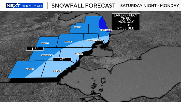
Once you get north and west of Ann Arbor, and west of Pontiac, the chance exists for some accumulation on the grass and raised surfaces in particular. Untreated roads, especially rural roads, may see some accumulation if snow can fall at a fast enough rate on Sunday morning. The snowfall potential is incredibly variable right now.
Thursday night was our first chance to measure the system coming off the Pacific Ocean with weather balloons, which we call sampling. This will allow forecast models to get a better hold on numbers and allow us to provide an even more accurate forecast.
For now, expect our first snowfall, light with some minor accumulation, from Saturday night to midday Sunday.
I have to emphasize that the data will change as we get more info, so stay with the NEXT Weather Team for updates as we get closer to our first flakes.