Tracking rain and snow across Colorado, a few degrees could make all the difference

A stronger and wetter storm will move into Colorado Monday night through Wednesday, bringing widespread precipitation and an increasing chance for accumulating snow along the Front Range and I-25 corridor.
The system has trended both colder and wetter as two storms are now more likely to phase together. That raises confidence in meaningful moisture across Colorado, but snow totals remain sensitive to temperature, timing, and upslope.
A cold front arrives Monday evening with rain developing across the plains and snow in the mountains overnight. Snow levels will start near 8,000 feet.
Tuesday is the transition day. Temperatures fall into the 30s and 40s with widespread precipitation. Lower elevations, including Denver, will see mainly rain during the day while snow levels drop from around 7,000 feet to 6,000 feet.
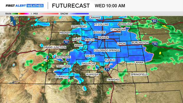
The key window is Tuesday night into Wednesday morning. That is when colder air and deeper moisture overlap, allowing rain to change to snow along I-25, including the Denver metro area.
Most likely snow totals:
- Denver and I-25 corridor: 2 to 5 inches
- Upper foothills (above 7,000 feet): 6 to 12 inches
- Front Range mountains: 10 to 20 inches
- Eastern plains: Mainly rain, with light or slushy accumulation possible
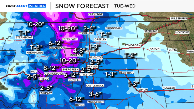
Higher totals are possible if temperatures cool a few degrees more, upslope strengthens, or heavier snow develops Tuesday night. In that scenario, parts of the Denver metro could see 3 to 6 inches or more.
A warmer or weaker upslope setup would limit accumulation and keep more precipitation as rain.
The bottom line: Snow is likely, but totals remain sensitive; a few degrees and wind direction can decide everything.


