Denver Weather: Unusually Cold Storm Arrives Tonight Bringing More Snow And Slow Travel
DENVER (CBS4) - A winter storm set to impact Colorado on Wednesday and Thursday will bring unusually cold air along with enough snow to create difficult travel conditions in many areas.
The arctic cold front on the leading edge of the storm will arrive Tuesday night causing high temperatures to drop from the lower 40s in Denver on Tuesday to the 20s on Wednesday. Then it turns even colder for Thursday and by Friday morning the Denver metro area will be close to zero degrees.
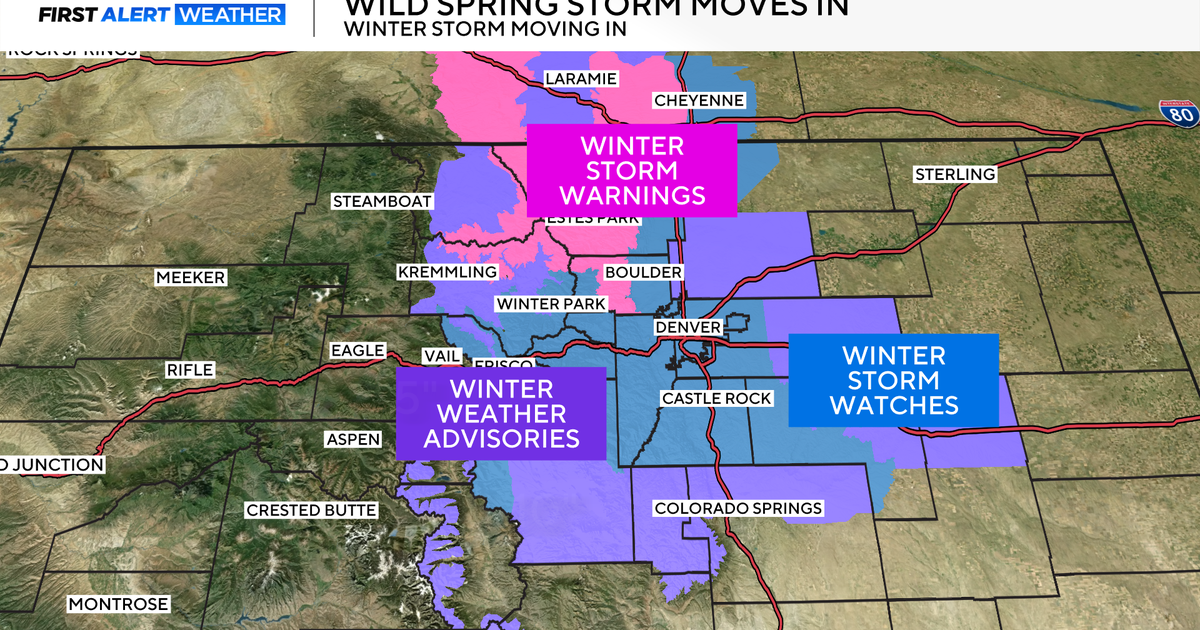
The heaviest snow with this storm will be found in the northern mountains including the Park Range and across the Flat Tops. These areas including Highway 40 over Rabbit Ears Pass and the Steamboat Springs area are under a Winter Storm Warning from 5 p.m. Tuesday until 11 a.m. Thursday for 1-2 feet of snow.
Most other mountain areas in Colorado are under a Winter Weather Advisory from 11 p.m. Tuesday until 5 p.m. Tuesday including the I-70 mountain corridor between Georgetown and Avon. Ski areas and many mountain towns will get 6-12 inches of snow creating great ski conditions but also major travel slowdowns.
There is also a Winter Storm Watch for far northeastern Colorado from 11 p.m. Tuesday until 5 a.m. Thursday for 4-8 inches of snow. The watch should eventually turn into a winter storm warning for areas like Sterling, Julesburg, Holyoke, Wray, and Burlington. Travel could become very difficult along I-76 east of Fort Morgan and I-70 east of Limon.
For Denver and the Front Range, snow totals will be less compared to the areas with watches, warnings, and advisories, but there will still enough snow in the metro area to create slick and slow travel. This is why the CBS4 Weather Team has issued First Alert Weather Days for Wednesday and Thursday. The afternoon and evening commute on Wednesday and the morning commute on Thursday will be impacted.
Snow will also come gradually to the Denver, Boulder, and Fort Collins areas. A few snow showers are possible Tuesday night as the arctic cold front arrives but no accumulation is expected. Then 1-2 inches of snow is in the forecast during the day on Wednesday followed by another 1-3 inches Wednesday night. Then it's possible there could be another 1-2 inches on Thursday before the snow ends mostly before 5 p.m. Thursday.
So for the vast majority of areas, total snowfall will be 2-7 inches. The northern foothills (north of I-70) could see more.
Looking ahead to Friday, the day will start with frigid temperatures for March. Denver, Boulder, and Fort Collins should be close to zero degrees. Then sunshine will help push temperatures above freezing Friday afternoon. A bigger warmup will arrive for the weekend.
