Denver and other parts of Colorado bracing for big weather pattern change by the middle of the week

Denver is bracing for a significant pattern change by the middle of the workweek.
It has been about a month-and-a-half since any notable weather has affected Colorado's Front Range, or much of the state, for that matter.
Our next system will arrive Thursday morning, starting as rain across the Eastern Plains and snow in the high country. I'd expect a wet Thursday, with some areas receiving up to a half-inch of rainfall.
Things get more interesting Thursday night into Friday. The first accumulating snow is expected along the Palmer Divide (south of the Denver metro area and just north of Colorado Springs) and in the foothills. In Denver, the storm track is currently too far south and too weak to support meaningful snow accumulation.
I do anticipate flakes mixing in overnight downtown, but it looks too warm at this point for any impacts.
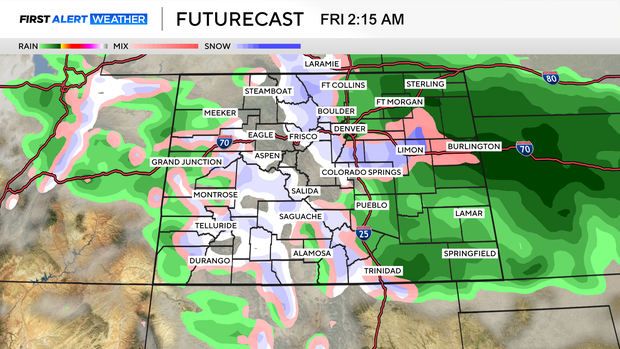
Right now, a general 1 to 4 inches is possible along the Palmer Divide. Given the warmer nature of the storm, accumulations will be mostly limited to grassy surfaces.
A general 2–5 inches will be possible in the foothills, with some roads snow covered.
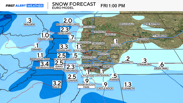
This storm will produce light snow across the mountains, with a general 2–5 inches expected. Wintry travel conditions should be anticipated during the Friday morning commute along I-70.