Colorado's snowpack hits peak: Will it hold or rapidly melt away?

Today, April 7th, marks the historical peak of the snowpack across Colorado.
With that said, it is a good time to check in on the snowpack and see where we are across the state.
A weak La Niña remains in control in the equatorial Pacific. This generally leads to the northern mountains receiving at or above average snowfall, with well below average snow amounts south of I-70.
To no surprise, the northern mountains are at or above average, while the southern mountains are lagging significantly.
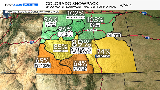
The statewide average is 89% of normal. This is up from 84% a little over one week ago, thanks to a roughly one-week stretch of active weather.
April tends to be an active month in the weather world, often bringing several storm chances each week. This week, however, is expected to be sunny and dry, so the snowpack will lag even further below average.
Maintaining the snowpack later in the season is essential. An early melt can lead to issues.
Snow has a "high albedo," meaning it reflects a significant amount of sunlight back into space. When there is no snow, the sunlight is absorbed by the ground. The ground then heats the air around it, causing the ground to dry out and leading to even more melting of any nearby snow.