Colorado fall colors: 12 recommended drives to witness the expected vibrant autumn leaves of 2023

With a bright and vibrant fall color season already underway, you may be wondering what a good drive might be to get a great look at the show for 2023.
There are many areas to get a good look at the change from summer to fall and the beautiful leaf shift across the state. When you head out don't forget to pack your camera and maybe a jacket for the fall chill that you might encounter.
Let's start up north.
Red Feather Lakes
This route west of Fort Collins is actually a loop that will take you into the Roosevelt National Forest.
You can start the drive north on Highway 287 just outside of Fort Collins to the town of Livermore. From there take Red Feather Lakes Road. Once you get close to the halfway point of the loop you should run across Potbelly Restaurant south of Red Feather Lakes. From that point look for Manhattan Road/Colorado Road 69 which will get you to the town of Rustic. From there you can connect with Colorado Highway 14 east back to Fort Collins.
Rocky Mountain National Park
This is a gorgeous drive that will most likely take a full day. If there are any cold fronts coming through it is wise to check conditions on Trail Ridge Road as sometimes it does close if there is ice or snow.
From Denver take highway 36 through Boulder, Estes Park and straight into the park, using Trail Ridge Road. Enter Rocky Mountain National Park and follow the road to Bear Lake. One of the best places for viewing the aspens is the area around Glacier Gorge Junction. There is a chance along this trip to see and hear a few bugling elk doing their thing to welcome the Fall season.
Guanella Pass
If your short on time, Guanella Pass might be a great option for it's proximity to the Denver metro area and depending on traffic is about one hour long. You will travel through the Arapaho and Pike National forests on your way from I-70 to US 285. You can drive to an elevation of 11,669 feet from either side. Starting in Grant on 285 or in Georgetown on I-70.
From Denver take I-70 west and exit at historic Georgetown. Follow county road 381 over Guanella Pass to the town of Grant for some spectacular aspen viewing. This is also a great time to ride on the Georgetown Loop Railroad. A steam locomotive will take you on a scenic ride to Silver Plume.
Peak to Peak Highway
You may want to plan the whole day for this one. Although the trip itself may only take a couple hours you start the ride in Estes Park or just outside of Black Hawk.. The Peak to Peak Highway, or scenic byway begins as State Highway 7 in Estes Park. You will travel through the small town of Allenspark on state highway 72. Heading south on State Highway 119 the trek goes through Black Hawk and Clear Creek Canyon to I-70.
If you tackle the 55 mile route from Black Hawk, start on U.S. 6 through Clear Creek Canyon, take highway 119 past Blackhawk and Central City up to the mountain town of Nederland. Look for highway 72 heading to Ward and Allenspark. You should see thousands of acres of golden aspen with the Continental Divide as the backdrop.
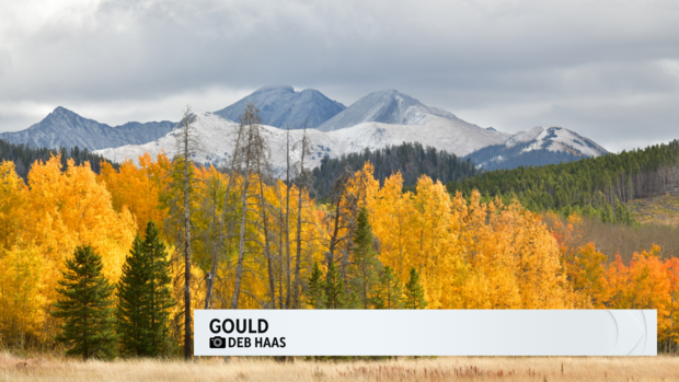
Poudre Canyon
Poudre Canyon goes by several names. The Cache La Poudre Canyon and The North Park Scenic Byway. The Cache La Poudre River got its name when French-Canadian trappers during winter time would hid or "cache" their gunpowder along the river.
The Byway is a 101 mile paved drive that again depending on traffic may take about 3 hours mostly thru the Roosevelt National Forest. The drive will take you over Cameron Pass just east of Gould and connects Fort Collins and the town of Walden.
From Denver take I-25 north to exit 269. Take Colorado 14 west through Laporte and into Poudre Canyon. You will be driving through Roosevelt National Forest. On this drive you will go over Cameron Pass and have a good look at the Medicine Bow Mountains.
Aspen
This is Colorado! Seeing the Aspen groves change colors in the city named after them is quite a treat. Fall is one of the most spectacular times of year in Aspen.
From Denver, take I-70 west to Copper Mountain, where you will follow highway 91 through Leadville to highway 82. the aspen should big and bold as you travel from Twin Lakes over Independence Pass and down into the town of Aspen. Before you leave it might be with getting a reservation and take a little detour to one of the most photographed mountains in North America. The Maroon Bells! Also, check out the John Denver Sanctuary while you are in Aspen.
The I-70 Corridor
Driving Interstate 70 is one of the easiest ways to check out the changing of the seasons. Just drive west into the mountains. Going from Denver west on Interstate 70 all the way to Avon should get you to some awesome views of Colorado color. The sights are awesome as you travel from Vail Pass to Avon. The aspens will highlight the slopes on both sides of the interstate.
Hoosier and Boreas Pass
If you have some time you could loop these two passes together and get spectacular views of sunny, yellow aspen groves along the way. The loop itself will take you from Boreas Pass to Fairplay and over to Hoosier Pass along an abandoned railroad grade.
From Como, drive US Highway 285 south toward Fairplay. In Fairplay, take a break at the South Park City Museum where you'll learn more about early railroading and life in a western mining camp.
From Fairplay, follow Colorado Highway 9 north to Alma where the valley of the Middle Fork of the South Platte River is lined with extensive aspen forests. Finish your drive back to Breckenridge by heading up and over Hoosier Pass where you can stand on the Continental Divide and take in the views of the Blue River valley. Allow several hours for this 55 mile loop.
The Hooser trip can also be done starting out near Breckenridge. Go west along I-70 to the Frisco exit and head toward Breckenridge on highway 9. Continue over Hoosier Pass down into the towns of Alma and Fairplay.
Boreas Pass also can be accessed near Breckenridge. Again go west along I-70 to the Frisco exit and head south through Breckenridge on highway 9. Look for Boreas Pass Road on the south side of Breckenridge. Follow the road around 14.5 miles to the town of Como.
West Elk Loop
Driving this entire route is a long one. You may consider spending a night somewhere along the route. It takes 6 to 8 hours to complete. But, you will see some of the most beautiful parts of Colorado. Including several national and state parks along the way. Like the White River and Gunnison National Forests, the Black Canyon of the Gunnison National Park, Curecanti National Recreational Area, and Crawford and Paonia State Parks.
From Denver, take I-70 west to Glenwood Springs where you will follow highway 82 south to Carbondale. Take highway 133 through Carbondale and continue over McClure Pass, there you will find one of the largest expanses of aspen in Colorado. The loop will take you through Paonia, where you'll head east on highway 92 to Gunnison. The loop back takes you on highway 135 to the ski town of Crested Butte where you'll drive a gravel road over Kebler Pass and then back to Carbondale on highway 133. This is a longer trip but, well worth it.
San Juan Skyway
This is considered one of the most scenic drives in America. You might plan this one in early to mid October to hit closer to the peak change. This route is in southwestern Colorado and will take you through many historic towns along with viewing the spectacular Autumn colors of the San Juan mountains. Some of the towns include Durango, Silverton, Telluride and Ouray.
The San Juan Skyway starts in Durango and travels north on U.S. 550 to Silverton where you'll follow the "Million Dollar Highway" over Red Mountain Pass down through Ouray (Colorado's little Switzerland) and into Ridgeway. Take Highway 62 over Dallas Divide on your way to Placerville where you'll want to turn south on highway 145 and head toward Telluride. Continue over Lizard Head Pass down to Cortez. Heading east on U.S. 160 will return you to Durango.
I might also, add this is a great drive in the summer when all the wildflowers are blooming.
Cottonwood Lake and Pass
The pass is filled with tons of aspen and cottonwood groves and will give you a nice mix of yellow, red, and orange fall colors.
Take U.S. 285 south from Denver to Buena Vista. Drive about seven miles west of Buena Vista on Main Street, and turn left on county road 344. You'll find Cottonwood Lake about four miles down the road surrounded by beautiful groves of Aspen.
Poncha Pass
This is a pass in south-central Colorado. It runs from the San Luis Valley to south and over to the Arkansas River Valley to the north. It is also, one of the lowest mountain passes in the state. In late September to early October you will typically find incredible color in stands of aspens along the San Luis Creek.
Take U.S. 285 south from Denver, or from Pueblo take U.S. 50 to Poncha Springs. Continue south on us 285 over Poncha Pass.
If you are planning on taking a trip to see the fall colors this year please snap some photos and send them to CBSColorado. We would love to display your leaf peeping photographs on our platforms including TV, web, stream and social media.