Colorado drought improves slightly, but extreme conditions remain

A rare May snowstorm brought much-needed moisture to Colorado this week, helping chip away at drought conditions across parts of the state, but experts say it was far from a drought-ending event.
"These are the kinds of storms Colorado has been missing for much of the last six months, so it's encouraging to finally see one, even here in May," said State Climatologist Russ Schumacher. "But we still have a long way to go. It's going to take much more precipitation to make up for the significant moisture deficits we've built up over time."

Denver officially recorded 5.8 inches of snow at Denver International Airport during the latest storm system, according to the National Weather Service. That's well above the city's average May snowfall of 1.4 inches. While snow in May is not unusual for Colorado, storms of this magnitude this late in the season are much less common.
However, much of the storm's impact is not yet reflected in the latest U.S. Drought Monitor map released Thursday morning. The drought monitor uses data that cuts off Tuesday morning, meaning a large portion of this week's rain and snowfall will likely not appear until next week's update.
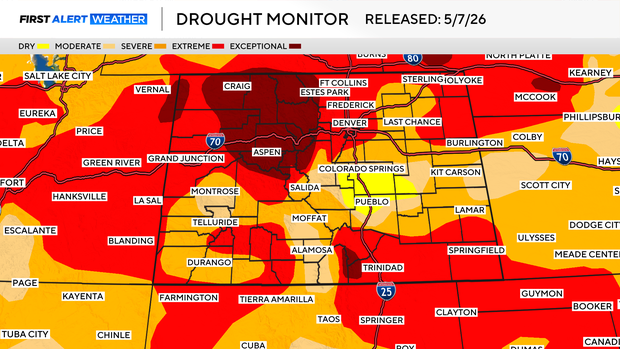
Parts of the northern and central mountains remain in exceptional drought, the highest and most severe drought category. The Denver metro area also continues to sit in extreme drought. There was some improvement across southern Colorado, where portions of Teller, Fremont, El Paso and Pueblo counties improved from moderate drought to abnormally dry conditions.
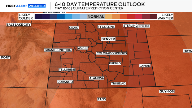
More warm and dry weather is expected next week, with temperatures climbing into the 80s across lower elevations. That warmer pattern could quickly dry out soils again and increase concerns about worsening drought conditions heading deeper into May.