How much has it snowed around Chicago?


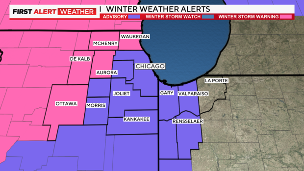
A Winter Storm Warning remains in effect for Kane, McHenry, La Salle, Lake (Illinois), and DeKalb counties, which could see snowfall totals of 8 inches or more, causing dangerous driving conditions through Tuesday night.
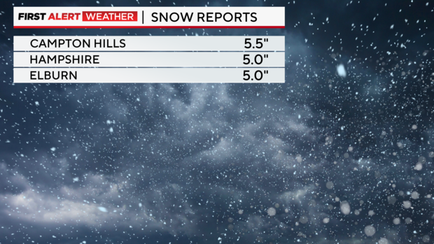
Wayne, Illinois had recorded 6.3 inches of snow as of Tuesday evening, DeKalb 6 inches, Campton Hills 5.5 inches, and Hampshire and Elburn 5 inches.
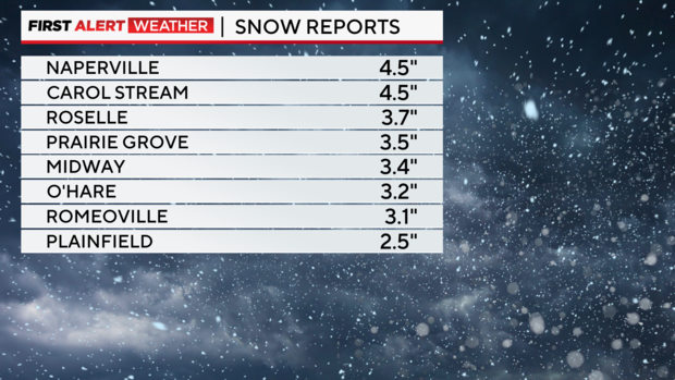
Naperville and Carol Stream had each reported 4.5 inches of snow as of Tuesday evening.
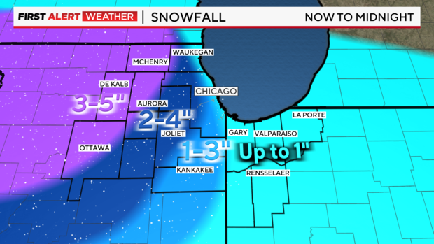
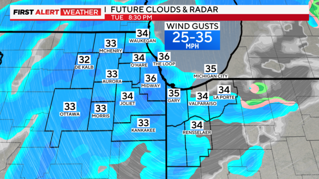
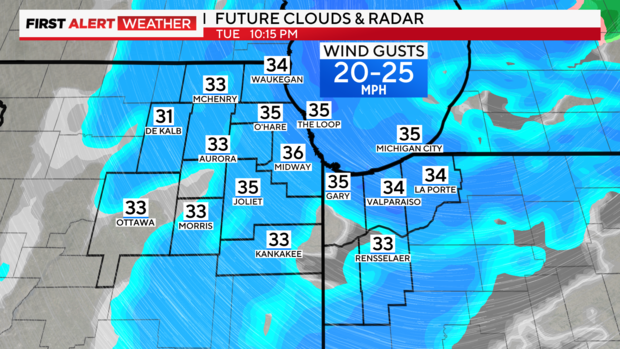
The graphic below represents not the total amount of snow expected in this snowstorm, but what is still expected to fall between the early evening Tuesday and midnight.
The parts of the Chicago area that are not under a winter storm warning are under a Winter Weather Advisory, where wet snow will lead to slippery travel conditions. The Winter Weather Advisory was extended to 4 a.m. for Cook and Will counties.
A Winter Weather Advisory was also issued for Northwest Indiana, but it was dropped by 10 p.m.
Steady snow west of Chicago
Steady snow fell through the day and night west of Chicago, with the heaviest snow expected through the late afternoon when snow could fall at rates over 1 inch per hour at times. This will result in significant accumulations in the northwestern suburbs, especially northwest of I-55 where over 6 inches of accumulation fell in some areas.
In the evening, total additional snow accumulations of 1 to 3 inches were expected across the area, with locally higher amounts near 3 to 4 inches possible for areas to the west.
Farther southeast, the snowfall gradient was sharp, with accumulations dropping off rapidly, including in Chicago. Temperatures were marginal for accumulating snow and above-freezing southeast of I-55, limiting amounts there. Scattered accumulating snow fell off and on areawide Tuesday evening.
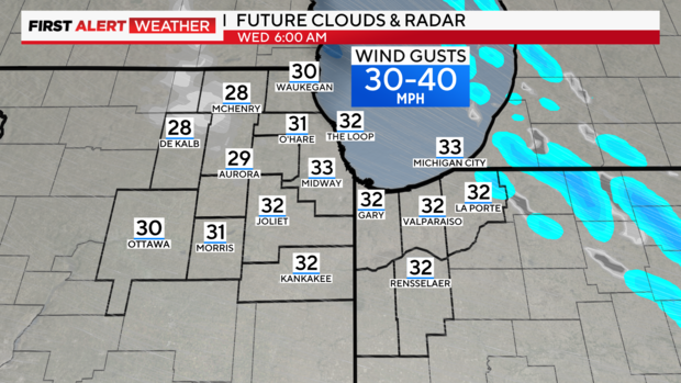
In addition, gusty northwest developed Tuesday evening and were expected to reach 35-45 mph at times. This was expected to result in areas of blowing and drifting snow, further reducing visibility and creating slippery travel conditions that could persist even into the morning commute Wednesday.
While the snow comes to an end early Wednesday, subfreezing temperatures may also lead to slick spots on roads for the morning commute. A Weather Alert remains in effect through Wednesday morning due to these travel concerns.
The two counties that picked up the most snow Tuesday were Kane and DeKalb County, so it will be this area with the best chance for morning blowing and drifting Wednesday morning.
Additional light accumulations of an inch or two are expected Tuesday night, as temperatures will fall below freezing area-wide.
These snowflakes were made for sledding
After a brief lull Tuesday afternoon, snow began falling heavily in the west and northwest suburbs. Around 1 p.m., a fresh coat of slushy, wet snow coated roads in Elgin. The National Weather Service reported Elgin got just more than an inch of snow just in the morning, and the snow kept falling through the night.
Snow plow trucks were out on the roads nonstop in Elgin Tuesday evening to get rid of the snow before it piled up. At the city's Public Works Department, workers were seen going in and out and loading up on salt.
The slushy snow came down quickly – catch some drivers by surprise. One such driver, Ganesh Subramanian of Elgin, tried to pull his van out of a parking lot - as its wheels were trapped under the snow.
"This is the first time I've experienced this," said Subramanian. "I've traveled in much worse weather than this, so it's really surprising for me that with weather like this, I got stuck."
In Woodstock thorugh the day, it was a similar pattern. A brief break ended around 1:30 p.m., and heavy snow began falling. It made for some nice sledding and snowball-making for the kids while the adults were inclined to shovel away the slick, slushy mess.
"I love it; it's fun to play with," said 10-year-old sledder Lucille Hagen. "If there is no snow, we can't go sledding and can't make snowballs and have snowball fights."
Lucille's friend, Mia, recently moved to the neighborhood from Florida. "When I moved to Florida (from Poland), there was no snow because it's warm. Then I moved here, and I was happy."
In Rosemont, thick flakes caused traffic headaches during the day, and busier roads were quickly becoming covered and slick.
In Villa Park, power went out in the middle of the snowstorm. ComEd told CBS 2 they have more than 800 crewmembers ready to combat possible outages – when and if they pop up amid concern about the wet, heavy snow on power lines.
As the second round of snow pounded the area in the late afternoon and early evening, CBS 2's Sabrina Franza also found some kids taking to the sledding hill in Robbins Park.
Slippery commutes in the morning and evening
In the morning, snow and rain affected drivers in Chicago's west and southwest suburbs. Snow on the ground mixed with active rain has caused slushy road conditions, causing cars to slide.
CBS 2's Mugo Odigwe reported slick roads on Route 53 in Bolingbrook and snow-covered roads in downtown Joliet during the Tueday morning commute. Snow-covered streets also impacted drivers in Hoffman Estates during the morning rush, as CBS 2's Marissa Perlman reported.
By midday, the snow had tapered off in Schaumburg, leaving a wet, slushy, heavy mess. But that didn't last. The snow was back by the evening.
Mary Santana stayed home Tuesday, but said it wasn't too bad outside.
"I thought it was going to be worse," she said. "It's just really sticky, slushy, and yucky."
By mid-morning, a steady rain fell in downtown Chicago and washed away any lingering snow on the ground. But by the early evening -- just in time for the evening rush -- the snow was back everywhere. Snow and rain fell off and on downtown through the nighttime hours.
In Aurora, CBS 2 spotted Corina Fowler Tuesday morning when she was the only person out on a stretch of Lake Street. She said she's done her job for decades, and she's got a routine: shoveling a path for herself and layering up under a Statue of Liberty outfit.
"I put an extra pair of gloves on because my hands were cold a little bit," Fowler said. "Because you get damp. When it's wet out here. Your body gets kind of colder quick because your hands are wet or your clothes are wet, but as long as you wear layers, you're all good."
Aurora street crews were out all day, keeping the roads and sidewalks clear.
Meanwhile back in Woodstock, one resident called the conditions "Christmasy." But commuters may not have had such rose-colored glasses about it all – as CBS 2's Kris Habermehl reported all the expressways leading into and out of Chicago were jammed early Tuesday evening.
A multi-semi-trailer-truck crash was reported at I-55 and I-80 southwest of the city during the evening rush, Habermehl reported just after 5 p.m.
Anyone who does get involved in a crash is advised to move to a place of safety and exchange information if the vehicles are both drivable and there are no injuries.
The Illinois Department of Transportation also reminded motorists to bow to the plow, as snow removal was under way during the afternoon rush.
Snow totals reported by noon showed the biggest amounts, about 3 to 3.5 inches, in Plainfield, Homer Glen, New Lenox, Palos Park, and Harvard. The official total for record-keeping at O'Hare was about an inch.
Airlines have reported flight cancellations at O'Hare and Midway airports. Check back for flight updates as the winter storm develops.
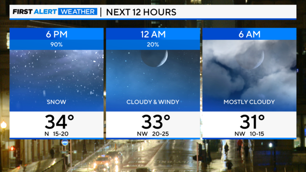
The snow will be ending overnight Tuesday into Wednesday.
There is another chance of snow Wednesday evening. Another inch of accumulation is possible.
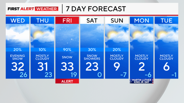
Another snowstorm on Friday
Another winter storm is possible Friday into Saturday with several more inches of snow accumulation and powerful winds. Once the storm departs, the coldest air so far this season arrives for the weekend into next week.
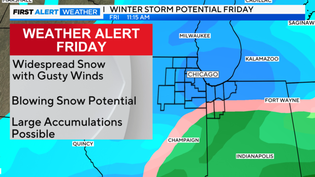
Behind this storm, we'll deal with the coldest air so far this season with temperature in the single digits starting Sunday and dangerously cold wind chills at night through Tuesday.
Forecast:
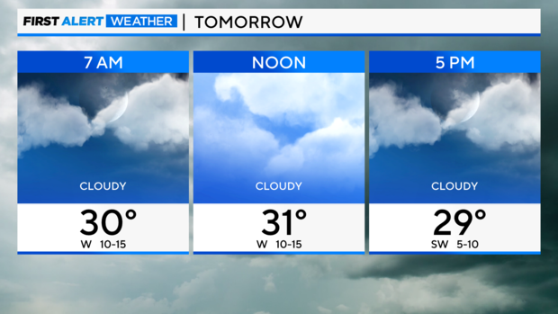
Tonight: Cloudy with snow ending overnight. Low 29.
Wednesday: Cloudy and blustery. High of 32. Chance of snow in the evening.
Thursday: Mostly cloudy. High of 31.
CBS News Chicago will continue to stream the latest on the forecast, flight delays and cancellations, and school closings all day. Watch it here or for free on Pluto TV.


