Blustery day Thursday in Chicago before snow on Friday

CHICAGO (CBS)-The impact of Wednesday's storm will still be felt during the early Thursday morning commute as crews continue to clean up the snow.
Thursday will be a blustery day with highs near 18 degrees. Lows drop below zero.
This second storm is on target to arrive this weekend, expect accumulating snow and travel impacts to start as early as Friday afternoon. Wind chills could reach as low as -10 by Friday morning.
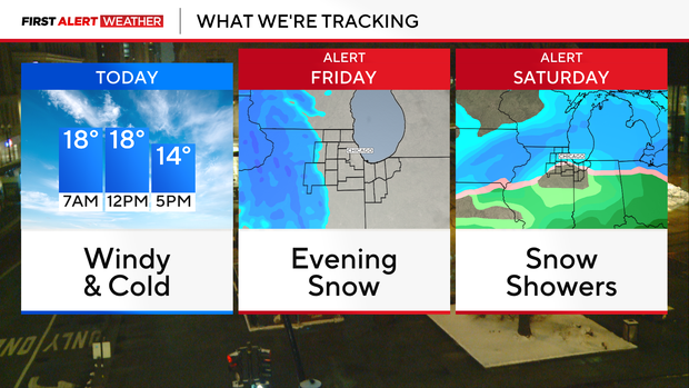
Two rounds of snow ahead for the weekend. The first round develops late Friday afternoon and ends in the evening. A quick 2 to 4 inches of snow are possible in the first round.
After a lull in the activity early Saturday, more snow develops for the afternoon and night. Snow lingers into Sunday morning while shifting into northwest Indiana. Right now, rain appears to stay to the south of I-80 with meaningful snow everywhere else. Travel will be hazardous once again throughout the day on Saturday.
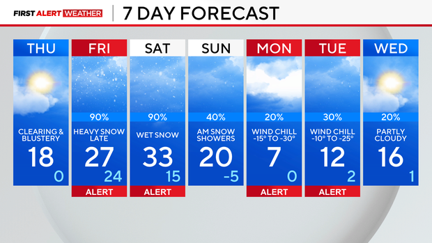
As the snow ends early Sunday, temperatures top off in the teens for highs.
Dangerously cold air follows for the start of next week.
Below-zero lows arrive by Monday morning, and wind chills may be as low as -30 degrees for the start of next week. A clipper system may bring another quick round of accumulating snow to the area Monday night into Tuesday.


