Nor'Easter Will Bring Heavy Snow, Power Outages And New Flooding
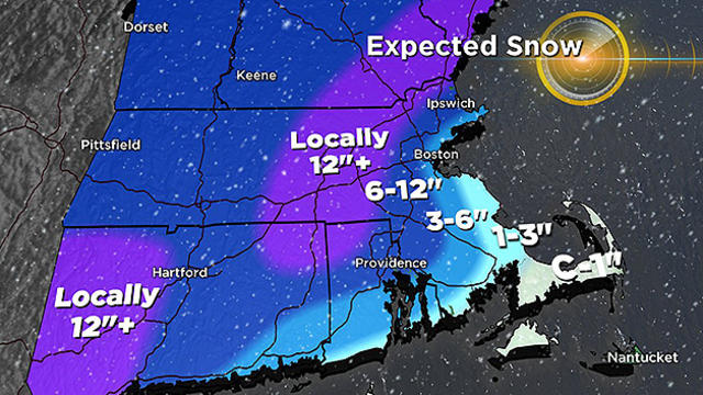
This will be a significant blow to all of southern New England.
Watch CBS News
This will be a significant blow to all of southern New England.

The rain-snow line will have very large consequences and effects from town to town.
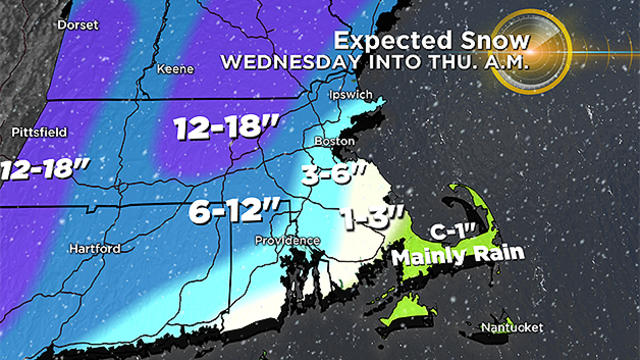
This storm will likely end up being the second biggest snow producer for us this winter.

We're not out of the woods just yet following a storm that wreaked havoc on the Massachusetts coast.

Here is a brief look at where we stand and what is still to come from this historic and dangerous storm.

This storm has the potential to be an historic, crippling event for southern New England.

Damaging winds, moderate to major coastal flooding, flooding rains and plowable snowfall are all in the mix.

Don't count out winter just yet. It is becoming more and more clear that Southern New England will see significant impacts from this developing monster of a storm.

We have some tremendous atmospheric changes on the way and a very active, wintry weather pattern over the next several days.
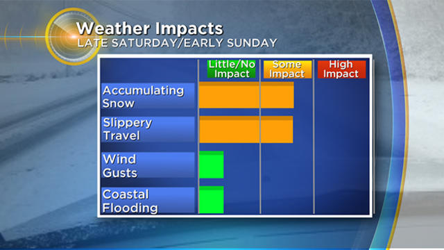
This weekend's snow will cause some treacherous travel on the roads and require some cleanup Sunday morning.

A highly disruptive winter storm will be very different from town to town.

It is looking increasingly likely that we will have a widespread, plowable snowfall on Wednesday.

It isn't always the big snow storms that cause the most headaches. Sometimes all it takes is a little snow coming at just the right (or wrong) time.

Were you one of those lucky folks to get 7-8" of snowfall this morning? No, you didn't miss a forecast update, this one was clearly under-forecast in some areas south of Boston.

A combination of ice, wind and heavy rain will likely cause some minor issues.

Here's what you can expect and when from Wednesday's storm.

The snow will make a mess of the Wednesday morning commute and likely cancel school once again for lots of towns.

A one-two punch of snow is coming in the next few days and our landscape is about to be transformed again, back to white.

We have a multi-faceted, highly impactful 24 hours of weather ahead with flooding rains followed by a flash freeze.

Here's what to expect in the next 2 days - temps in the 50's, thick fog, rain, thunder, wind, flooding, ice, snow and a flash freeze.

This week we are talking about near record warmth, heavy rain and flooding.
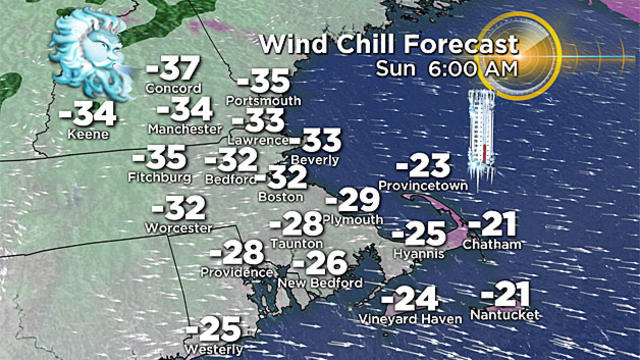
As cold as it has been, this weekend will be even colder. This is rock bottom.

The blizzard may be winding down, but the dangerous weather is far from over.

The Blizzard of 2018 is underway, it is going to be a wild day across New England.

The next several days are going to feature some of the most dramatic and dangerous winter weather we have seen in our lifetimes here in Boston.