Snow in the forecast for Massachusetts this weekend and it could be several inches
BOSTON - There is another snow storm on the way to Boston and most of Massachusetts this weekend.
It's not a blizzard or a nor'easter but it will likely be more snow than we have had in one storm in years.
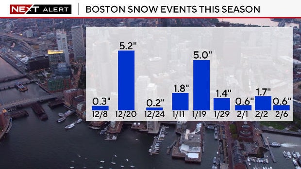
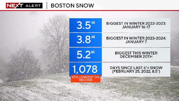
The last time Boston received 6" or more in one storm was Feb. 25, 2022, almost three years ago. And it's possible that Boston will get 6" or more this weekend.
Much like Thursday's storm, it will be another quick mover. The peak of the storm will only last about 8-10 hours.
There is a chance of some sleet mixing in near the southern coast. The snow may be followed by some freezing drizzle near and south of the Mass Pike on Saturday night and into Sunday morning.
When will it snow?
The start time for the snow has moved up by an hour or two.
There could be flurries in the air anytime after 6 p.m.
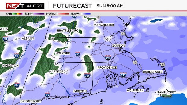
The steady snow will arrive:
Western Mass: Between 6 p.m. and 8 p.m.
Central Mass: Between 8 p.m. and 10 p.m.
Eastern Mass: 10 p.m. and 11 p.m.
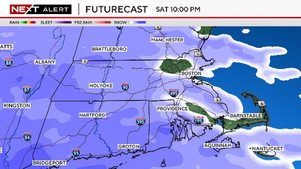
The majority of the snow accumulation will occur during the first few hours.
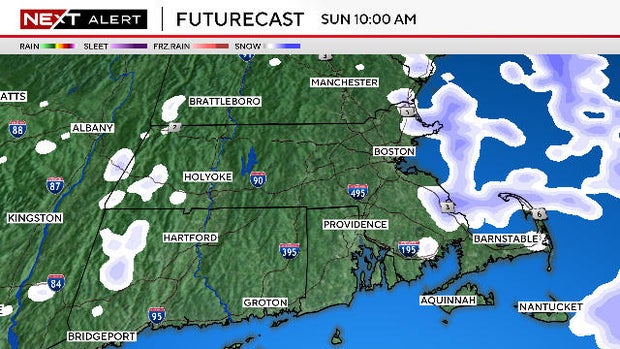
There will be some light snow and flurries, especially for northern areas, between 8 a.m. and noon on Sunday, but very little additional accumulation. Southern areas can expect to see some freezing drizzle and snow, but it should dry out after 12 p.m.
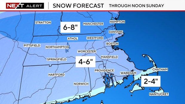
How much snow will Massachusetts get?
Currently, we are forecasting between 4-6" for most of southern New England. This would include Boston and Worcester.
Over the Outer Cape and Islands, a bit less, between 2-4".
The far northern ski areas will also be around 2-4" given their farther distance from the storm.
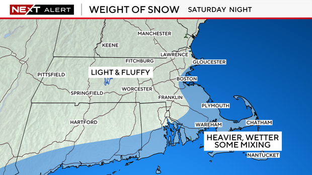
This storm is all about the snow. There will be no wind or coastal concerns.
On average, the snow will be on the light and fluffy side, especially west of I-95. The closer you live to the coast, the wetter and heavier the snow gets, especially over far southeastern Mass.
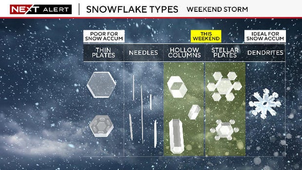
Types of snowflakes
One other thing to consider with this particular snowstorm: The type of snowflake.
In order to maximize our snow accumulation (like some of our biggest storms), you need the snowflakes to be formed and grow in a ripe portion of the atmosphere called the "dendritic growth zone." This is between -10 and -20 degrees.
In this particular storm, during most of the overnight hours when the snow is accumulating, the flakes will largely be forming below that zone (lower in the atmosphere). If that is the case, we likely won't see the perfect, six-sided dendrites.
Under perfect conditions, snow totals this weekend would be a bit higher than our forecast, but right now, it appears conditions will be less than ideal several thousand feet above our heads.
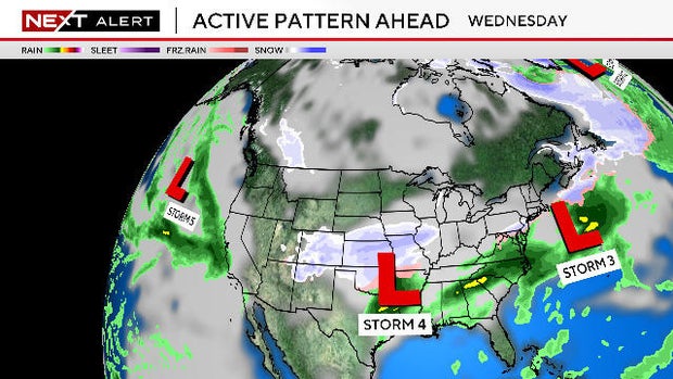
More storms in the forecast for Massachusetts
Temperatures following the storm will be near freezing Sunday into early next week allowing for some melting.
Speaking of next week, the active storm pattern will continue. There are likely to be multiple storms to watch, the first around Tuesday and then another around Thursday and perhaps another next weekend.
There is no guarantee with those storms though:
Tuesday's storm could end up being too far south and just fringe our area.
Thursday's storm could be another mixed precipitation event with ice and rain involved.
Next weekend's storm is just simply too far away to even speculate on.
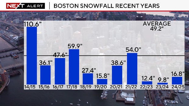
Bottom line, any comparisons to the snow-blitz of Jan-Feb of 2015 are greatly exaggerated. Sure, it is an active pattern, but to this point, we have a long way to go to even get an "average" snowfall season in Boston.
Our weather team will have you covered all weekend. Stay tuned for frequent updates on WBZ-TV, CBS News Boston and WBZ.com