Eastern Massachusetts could see heavy downpours Wednesday
By Terry Eliasen, WBZ-TV Meteorologist, Executive Weather Producer
BOSTON - The WBZ Weather Team is issuing a NEXT Weather Alert likely lasting through part of the afternoon Wednesday.
Currently, there is an area of disturbed weather just to the north of Bermuda. The National Hurricane Center is keeping tabs on it in case there is some development.
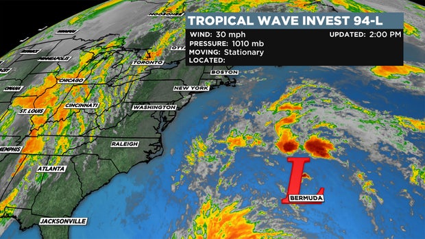
However, the chances of a tropical depression or storm forming are lowering, currently at just 20% (down from 70% Monday). Whether they give it a name or not, we do not expect any sort of tropical impacts or concerns here in New England. The only question is how close the rain shield will get to our coastline.
An area of showers will pass to our east (offshore) during the day Wednesday. This will be a very close call with regards to some heavy downpours.
Most models place the area of heavy rain very close to the Massachusetts coastline Wednesday morning through the mid-afternoon.
By 2-3 p.m. the rain will have largely moved to our north and east, up into Maine and beyond.
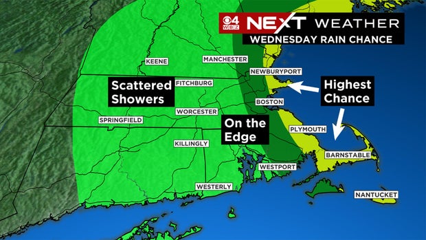
So, the best chance of any impactful rain would be areas farther east including Cape Cod, Cape Ann and Downeast Maine. There is potential for 1-2" of rain in some isolated, coastal areas. To the west of I95, expect just some scattered showers through the first half of the day Wednesday.