Snow in the weather forecast? Unusual storm could bring flakes to Massachusetts Saturday.
Believe it or not, the possibility of snow is in the weekend weather forecast for part of Massachusetts. It would be one thing to have a rainy day, like last Sunday, but the forecast for this Saturday truly takes the cake and has even our weather team shaking their heads.
We have issued a NEXT Weather Alert for Saturday for a very chilly, wet and windy spring storm in the Boston area.
This is a highly anomalous storm for a number of reasons.
Omega Block affecting Boston weather
Take a look at the jet stream forecast in the coming days. You don't need a degree in meteorology to recognize that something isn't right.
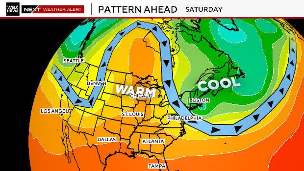
There will be a huge ridge of high pressure extending from the Midwest way up into Canada. This will bring record heat to areas up near Hudson Bay, with temperatures expected to top 80 degrees. Conversely, major troughs in the jet stream will form on either side of that giant ridge, one in the Pacific Northwest and another right over New England.
This specific configuration is known as an "Omega Block," and when you get this much twisting and turning, some wild weather is bound to occur. And, wouldn't you know it, New England is in just the right (or wrong) place.
The storm is literally coming right out of the Arctic Circle and making a beeline for our backyard.
Boston weekend weather forecast
The storm will peak during the day on Saturday when a band of windswept rain will pivot from north to south across central and eastern Massachusetts.
It will have the feel of a nor'easter at times on Saturday, with strong northeast winds pushing waves of rainfall inland.
Winds will gust between 30 and 50 mph within that band of heavy rainfall, perhaps even leading to some minor tree damage.
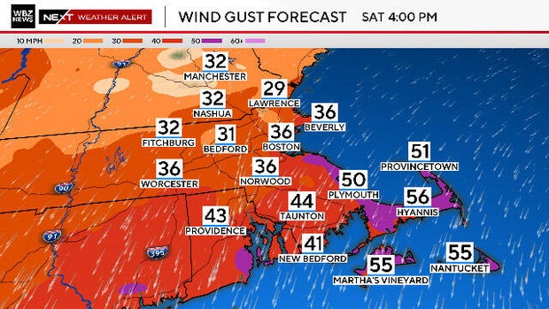
The strongest winds will be located across northern areas Saturday morning and then pivot over southeastern Massachusetts during Saturday afternoon and evening.
Record low temperatures?
Temperatures during Saturday will be very chilly. A good portion of central and eastern Massachusetts will dip into the mid 40s during the afternoon, some 25 degrees below the average high temperature.
We have a shot at setting a new record low maximum temperature on Saturday in Boston. The old record of 51 degrees occurred five years ago during that dreadful Memorial Day weekend deluge.
The bizarre thing about temperatures on Saturday is that the highs will occur in the early morning hours (just after midnight) and then drop off during the day. So technically, by the record books, the high for the day is likely to be somewhere in the mid to upper 50s. In reality, during the daylight hours, temperatures are likely to be below the old record.
Snow chances
For the entire event and across all of New England, the precipitation will be falling as snow out of the clouds. The atmosphere above our heads will be below freezing from the top all the way down to about 3,000-4,000 feet. So, many of the higher peaks in northern New England will actually receive a few inches of snow.
As the snow falls into the slightly milder air below 3,000 feet, it will change over to rain and that is what most of us will see throughout the storm.
Snow falling on Mount Washington this weekend would not be all that unusual. They average about a foot of snow in the month of May. However, it will be interesting to see if some wet snowflakes mix in as far south as the Monadnock region or even northern Worcester County.
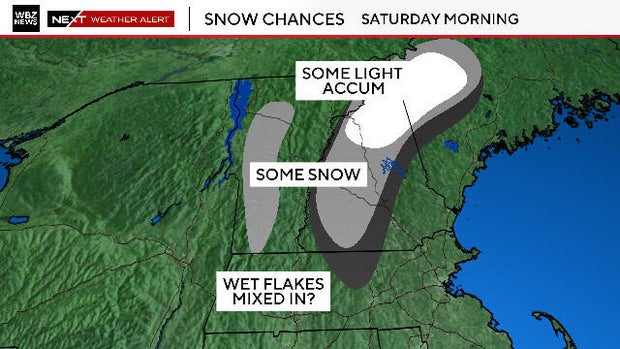
The air is so cold aloft during this storm, all it would take is a burst of heavy precipitation to briefly draw down some of that colder air to the surface. Be on the lookout.


