Widespread snow is expected in Massachusetts Tuesday

It's time for snow in Massachusetts. The first significant widespread snowfall of the season may be coming Tuesday.
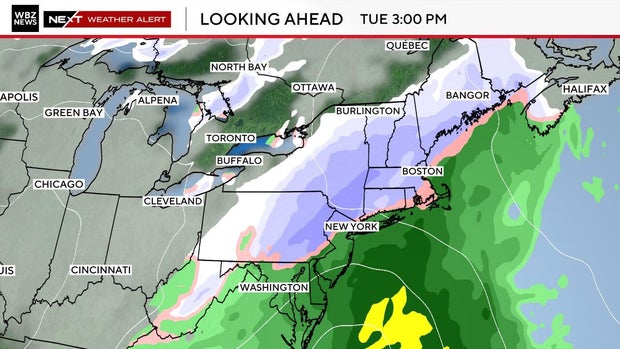
A storm sliding south and east of New England will throw moisture into the air that is cold enough in the interior. Along the coast, temperatures sit just a little too warm. That sets up a classic early-season mix of rain, sleet, and heavier snow in the higher terrain.
The WBZ-TV weather team has issued a Next Weather Alert to help you plan ahead.
Who gets the most snow?
This is not a blockbuster storm, but the setup favors higher terrain and communities inland.
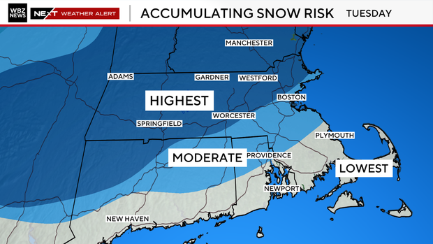
The risk for plowable snow is highest across central and western Massachusetts, including the Berkshires, Worcester County, and Middlesex County.
Vermont and New Hampshire will also be under the threat of some heavier snow. These areas have the best chance for a snowfall that will require some cleanup, especially Tuesday evening's commute.
Further south and east, the accumulating risk drops, stretching roughly from northern Rhode Island into the I-495 belt and parts of MetroWest. Snow may mix with sleet or rain at times, which could limit how much sticks, but brief bursts of steady snow are possible.
Closer to the shoreline, including Boston, the South Shore, and southeastern Massachusetts, the lowest risk for accumulation is in place. Warmer air near the ocean means coastal locations will see rain, with only brief wet snow mixing in. Any whitening near the coast would be patchy and short-lived on the back edge as the system departs.
When does the snow start?
Snow or a rain and snow mix could arrive as early as Tuesday morning and become steadier ahead of the evening commute. The interior could see slick spots as temperatures hover near freezing, while the coast deals with a chilly, rainy mix. The storm moves out overnight into early Wednesday morning.
If current trends continue, the interior will likely be the focus for shovel-worthy snow, while coastal locations stay mainly wet. The highest risk for accumulation may need plows for the first time this season.
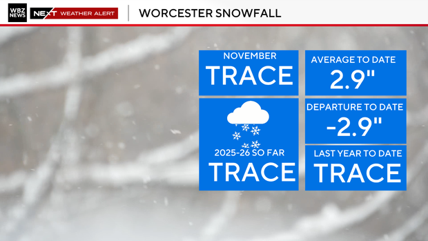
Slow start to snow season
There's been a slow start to the snow season in Massachusetts so far.
Worcester has at least picked up a dusting this November. It's not zero inches, but it's not enough to be considered measurable.
Boston, meanwhile, is still waiting for the kind of storm that reminds the city that winter actually exists.
Last significant snow in Boston
How long has it been since we've had a significant snowfall in Boston? Nearly four years.
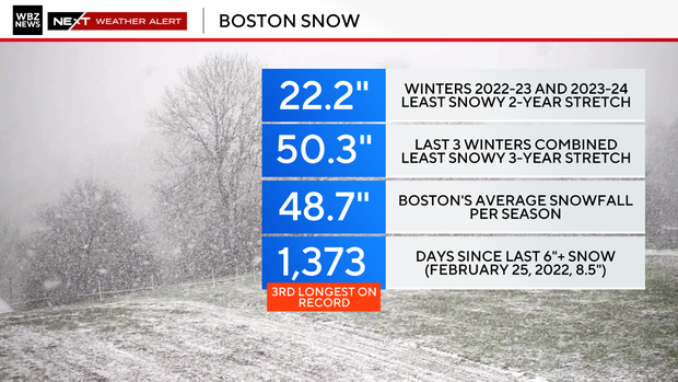
It's been 1,373 days and counting since Boston's last six-inch or greater snowstorm. That streak stretches back to February 25, 2022. That's when 8.5 inches of snow fell at Logan Airport in Boston.
The recent trend tells the same story.
The last three winters combined produced 50.3 inches of snow, only slightly more than what a single average winter brings. A typical winter in Boston is 48.7 inches. The city has not seen a true heavyweight storm in years.
Bottom line
The bottom line is that Tuesday's storm will not break any records, but it's a meaningful step toward winter.
For snow lovers and for plow drivers, this may be the first event that feels like the start of something.
The WBZ-TV weather team is predicting 55 to 65 inches of snow in Boston this winter and 75 to 85 in Worcester.