It's Crunch Time
It's a topsy-turvy morning because it is warmer at the observatory at the summit of Mt.Washington than it is in most of the region closer to sea level. At 8am, it was 16 degrees with a visibility of 120 miles on the top of the rock pile while most of the suburbs had frosted cars with temperatures in the single numbers with poor visibility in spots due to fog. This temperature inversion was created under premium radiational cooling conditions during the night when it was clear and calm with enhancement by a deep snow cover. Just prior to daybreak, areas of low clouds formed plus a shield of high cloudiness streamed in from the approaching storm.
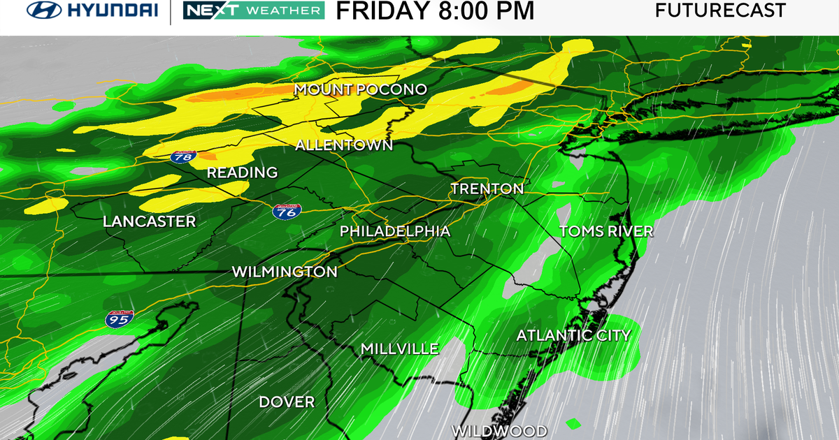
The region of low pressure to the south of us is split into two pieces. A glance at the composite satellite/radar loop reveals a very interesting portrait of the system. The initial impulse is blossoming northeastward and heavy snow is breaking out over New Jersey into NYC to southwestern CT. This shield of precipitation should expand across southern Connecticut and southern Rhode Island by late morning or so with some of that area perhaps receiving 1 to 3 inches through early to mid-afternoon. There is a slight risk it will blossom up to near the Mass Pike during the afternoon with less than an inch. On Cape Cod and the immediate South Coast, some mixing or a change to rain is probable. This first wave will shift offshore this evening leading us to discuss part two. This feature is an upper level low pressure system over Tennessee this morning and it is the master key to the forecast. Currently, it is tracking almost due east. If it continued on this trajectory, little or none of its precipitation would make it into New England. I expect a gradual turning of the system to slightly north of due east later today then more east-northeast tonight then more northeasterly tomorrow morning. The precise timing of this turning will be paramount to accurately predicting the amount of snow that will penetrate into New England. At this time, It appears that sufficient dynamics will pinwheel into the region to provide a spell of moderate to heavy snow for the Boston area southward from near 11pm to about 4-5am. As a result, I am sticking with my expected snowfall totals from the past couple days. The final snowfall amounts will range from nothing more than a dusting up to 3 inches across southern York County in Maine, extreme southern NH into extreme northern MA into western MA up into extreme southeastern VT. The 3 up to 6 inch ribbon should run across central and southern Essex County, central and southern Middlesex County into Suffolk County and northern Norfolk County. The immediate Boston area is in line for 5 possibly 6 inches. The 6"+ belt extends south of Boston to just east of the Cape Cod Canal across most of Rhode Island. Within that belt, there will be areas of 8 to 9 inches possible in Plymouth County and Bristol County into southern Rhode Island. I am also revising the numbers higher into at least the 3 to 6 onch range for much of the Cape. It is entirely possible that the 6+ belt may be shifted onto at least the inner Cape. Lower amounts are likely on the outer Cape and Nantucket due to some rainfall and mixing for part of the storm. The disorganized zone of low pressure will replaced by the final deepening storm off Delmarva this evening which will track east-northeastward well south of New England.
Every storm contains a surprise so the surprise that I think that we need to be prepared for is the possibility that the amounts will be lowered further north and west of Boston and raised even more on Cape Cod. That is where potential failure may exist. In any event, the storm is a done deal by dawn and some sunshine returns tomorrow. There is a risk of some splashover at the usual shore roads about an hour or so either side of the 5Am high tide tomorrow as the northeasterly wind increases to 15-35 mph late tonight and backs to northerly closer to dawn. There could be a foot or more storm surge to add onto the scheduled 10.4 foot tide.
Looking ahead, a couple disturbances will pass through in the next few days. The first perturbation would only crank out some clouds with a slight risk of a flurry on Friday followed by the second one producing a little bit of light snow or flurries later Saturday afternoon or night. Temperatures max out around 30-33 through Saturday with colder 20s Sunday and Monday. Morning flurries along the coast will exit leaving sunshine for Sunday and Monday. The next storm is timed to arrive later Tuesday as snow but the arrival of milder air would cause a switch to rainfall Tuesday night. That scenario is speculative at this time.
If new data warrants any revision of the above discussion, I will post some midday musings early this afternoon otherwise Todd Gutner has the next chapter later in the day.