Damaging Winds, Flooding Possible As Hurricane Dorian Passes New England
BOSTON (CBS) - After making landfall for a fourth time (three times in the Bahamas and now once over Cape Hatteras early on Friday), Dorian is finally headed away from the U.S. mainland and out to sea. It is currently forecast to pass by New England early Saturday morning, some 100-150 miles or so off the Coast of the Outer Cape and Nantucket, and from there, it will batter the shores of Nova Scotia and Newfoundland over the Weekend.
As with all tropical systems headed northward through the Atlantic, Dorian will begin to undergo a metamorphosis from tropical to extra-tropical as it passes over much colder waters. However, the current National Hurricane Center forecast track actually has Dorian briefly strengthening again to a category 2 storm before making landfall in Nova Scotia later Saturday. One last gasp for a storm nearly 2 weeks old.
As for the impacts here in New England, it will be a fairly quick 6-10 hour burst of rain and wind for southeastern parts of our area...
TIMELINE:
The first rain bands were already coming ashore on Nantucket and Martha's Vineyard during the afternoon on Friday.
Bands of heavy rain will initially struggle to penetrate into interior southern New England, but after dark, some initial showers/downpours will rotate south to north, eventually reaching Boston and the northwest suburbs.
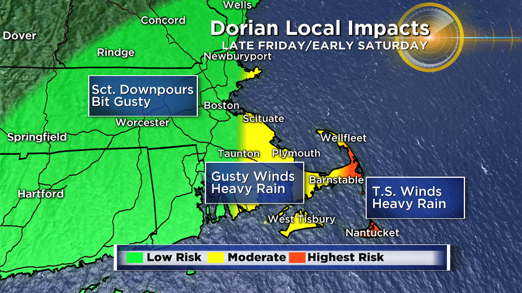
The steadiest and heaviest rainfall will come between 11 pm Friday night and 11 am Saturday. By Saturday afternoon, Dorian is accelerating well past our latitude, taking the wind, rain and clouds with it.
RAINFALL:
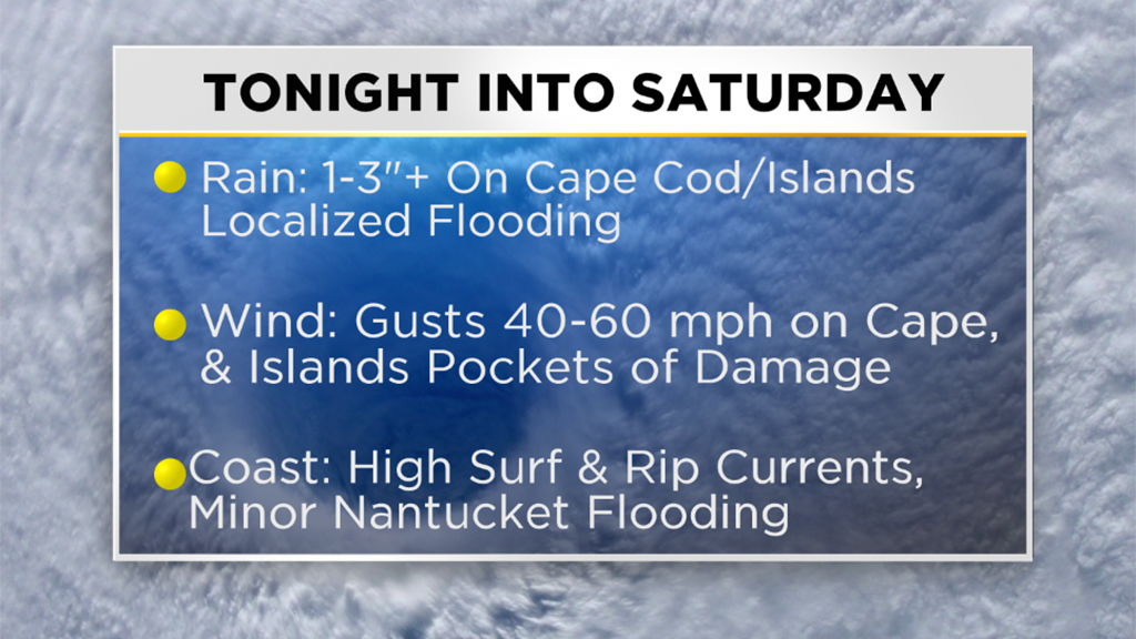
The highest rainfall totals will be in areas closest to the storm, Cape Cod and the Islands. We expect 1-3" of rain in these locations with the possibility of some localized flooding during some of the heaviest bands of rain early Saturday morning.
There is a chance that the Outer Cape and Nantucket could receive as much as 4-5" of rainfall.
Coastal areas from the North Shore, through Boston and through the South Shore will likely receive between .5"-1" of rain with lower and lower totals as you travel farther inland.
WIND:
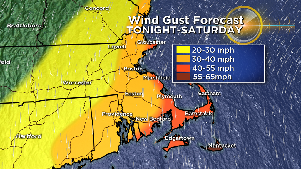
The strongest winds will also be located across Cape Cod and the Islands. Expect wind gusts between 40-60mph on Saturday morning, veering from east to northeast and finally to the north-northwest as the storm passes by.
A Tropical Storm watch has been issued for these areas essentially highlighting the potential for tropical-storm force winds (greater than 39mph). Some downed trees, branches and power lines are possible.
For the remaining coastal areas of MA, NH and VT, expect gusts between 30-40mph on Saturday morning. Inland of I-95, wind gusts will be much lower, in the 20-30mph range.
SEAS:
Obviously the seas will be very rough as Dorian passes by. 15-20+ foot seas are likely in our coastal waters east of Cape Cod and Nantucket. Some minor coastal flooding is possible between 6am and 10am Saturday on the north and east facing Cape Cod beaches and also the north side of Nantucket. Tides are NOT astronomically high, no major flooding issues or property damage is expected.
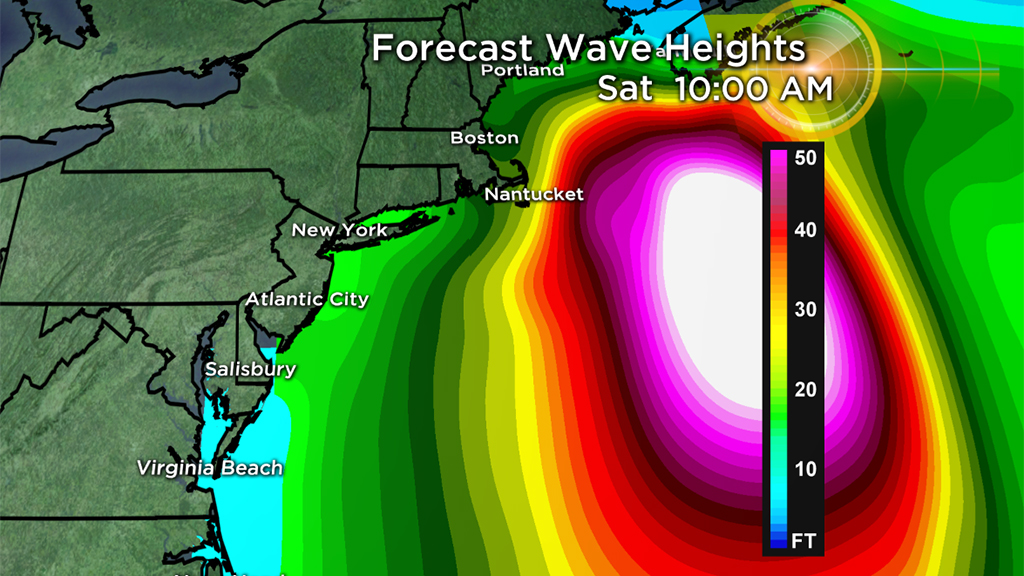
I do anticipate some large breaking waves at the beaches that could lead to some minor beach erosion. These large waves always draw people to the coast during an event like this, but be aware, those waves will be dangerous to anyone entering the surf, venturing out on jetties or viewing from sea walls. Spectators should stay in safe areas, away from possible splash over. The risk of rip currents will also be very high. A high surf advisory has been posted for parts of the area through Saturday.
As always, we urge that you stay tuned to WBZ-TV and CBSBoston.com for updates throughout the storm.


