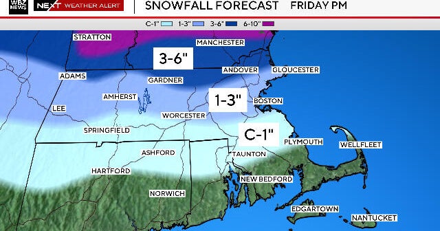
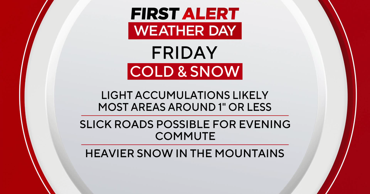
How much snow is Boston getting this weekend? Here's a closer look at the Massachusetts forecast.
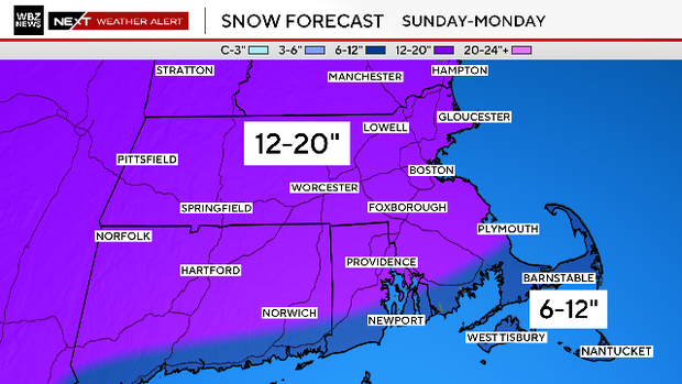
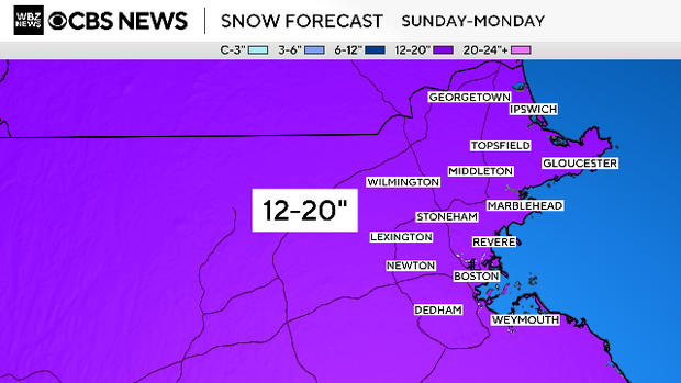
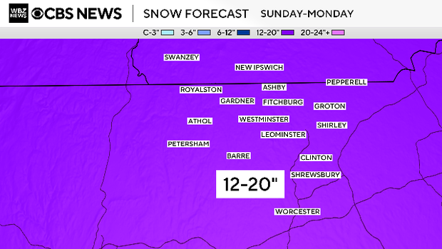
A major winter storm is expected to bring between 12 to 20 inches of snow to most of Massachusetts Sunday into Monday.
That's a pretty big range, so how much should you expect your town to get? And who's going to get the most snow?
There are many factors to consider that complicate the official WBZ-TV snow forecast - the amount of sleet and how long it will last, the coastal front sweeping through, the fluff factor, wind direction, heavy snow bands, and mild ocean temperatures.
Let's look at what we have so far.
Boston, North Shore and Upper South Shore
We feel pretty confident with our forecast here. I would guess that these towns end up in the middle or higher end of the 12-20" range.
There are some coastal front factors in here too, with temperatures warming up 10 degrees or more Sunday night. There is a significant chance that on Monday, some bands of snow will rotate from north to south over this area. This could end up pushing some towns here over the 20" mark.

Therefore, we have labeled this area as a potential "jackpot" zone. This is exactly what happened in the Presidents' Day storm in 2003. A last-gasp, localized band of snow dumped several inches in Boston, pushing the city over the record for a single snowstorm previously held by the Blizzard of 1978.
South of the Mass. Pike, including South Shore, Norfolk County
This area is within our 12"-20" zone.
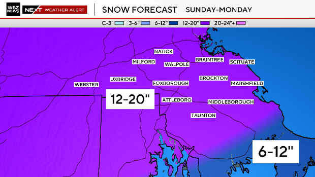
But the WBZ weather team is concerned about a few things in this area.
Sleet: If the sleet comes a bit farther north, towns like Taunton, Middleboro, and Marshfield might not make it to 12". We have toyed with dragging the 6-12" line a tad farther north. It could still happen.
Coastal front: A coastal front will set up Sunday night, and most of the towns here will warm up from the teens into the upper 20s and low 30s for several hours. This will make the snow wetter and heavier for a time, potentially weighing down what has already accumulated. For that reason, it seems unlikely that this area "overperforms."
Ocean enhancement: As cold air flows over the warmer ocean, it can sometimes create heavier bands that drop several more inches in coastal towns (same idea as lake-effect, but not as intense). These are near-impossible to predict, but they could lead to neighboring towns experiencing a rather large disparity in snow amounts.
North of the Pike, Worcester Hills, 495, Route 2
This area is the easiest one to predict. There is no doubt that towns here will stay very cold throughout the storm, and nothing but fluff will fall here. We expect the higher end of the 12" to 20" range here.
This is also our second and final potential "jackpot" zone. This should come as no surprise to those living here. This is the true snow-belt of southern New England. More often than not, this area always overdoes it.
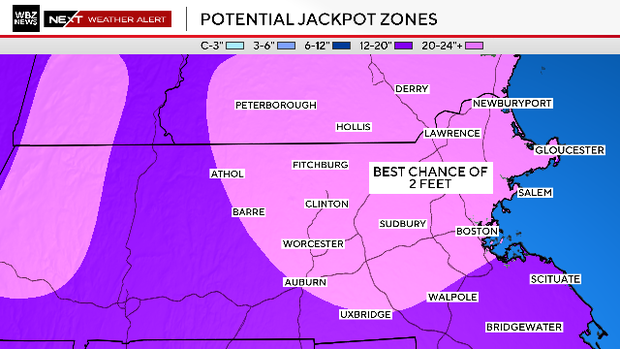
Definitely wouldn't be shocked if several towns here went over 20" and ended up closer to 2 feet of pure Arctic fluff.
Southeastern Massachusetts, Cape Cod and Islands
I'd say the biggest wildcard with this storm is the potential for sleet. It doesn't really accumulate, nor does it stick to things, but it does halt snowfall accumulation.
We expect a thin layer of warmer air (slightly above 32 degrees) to nose in about 5,000 feet above our heads Sunday night.
When this happens, the snow falling from clouds at much higher levels of the atmosphere passes through the warmer layer, melts into rain, and then refreezes as it falls back into colder layers near the ground.
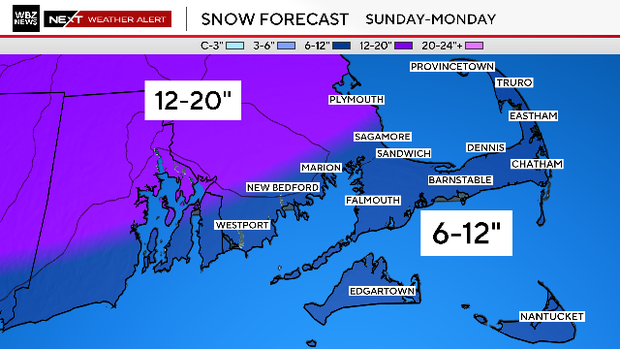
Currently, we think this warm layer will make it about as far north as Plymouth, and therefore, we have lowered our snow amounts south of Plymouth. The WBZ weather team is considering lowering the forecast here to 3" to 6" but we have not affirmed that yet.
The snow in the 6-12" zone will be much different from most other areas. It will start off rather light and fluffy early Sunday, but temperatures will rise throughout the day and into the night. Picture it as a snow sandwich. The bottom layer will be a bit of fluff, then some sleet pellets and rain, then finally a bit of snow on top from late Monday.