Groundhog Day Nor'easter Could Drop A Foot Of Snow In Mass.
BOSTON (CBS) -- Another major winter storm is headed for New England.
Check: Weather Blog | Current Conditions | Share Photos
With the Blizzard of 2015 still fresh in our minds, this will be one of the snowiest stretches in recorded history for Boston, Worcester and much of southern New England. Some towns in Middlesex and Worcester Counties will approach the 50" mark in just under seven days.
Remember back in the fall when western New York, places like Buffalo, were getting buried by several feet of lake effect snow? It seemed almost impossible that much snow could fall in one area over such a short period of time. . . well, winter of 2014-2015 is at it again, this time in our own backyards.
I suppose there is some silver lining to this Groundhog Day Nor'easter. Coming right on the heels of the big game tonight, there will be a lot of sleep-deprived adults and kids on Monday. No doubt, many schools will close this evening given the forecast. Monday would be an excellent day to work from home or take a snow day.
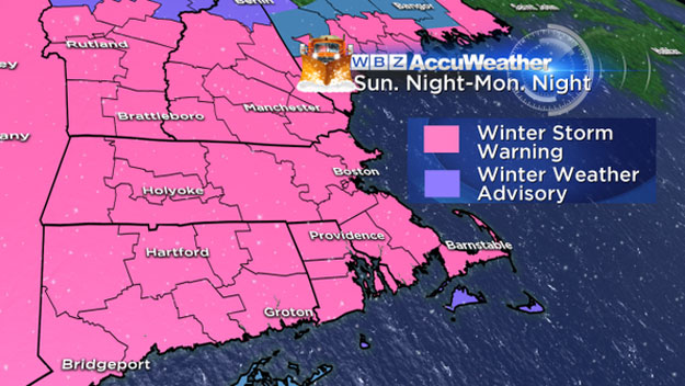
Lets break this one down inch by inch...
10 p.m. Sunday through 2 a.m. Monday:
The snow begins. . . a shield of snow will overspread the region from the southwest (Connecticut first) to the northeast (arriving in Maine last). There may some some coatings already on the ground as you head home from the Super Bowl party, depending on what time you leave.
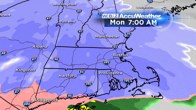
2 a.m. to 7 a.m. Monday
The snow ramps up quickly. By dawn on Monday, snowfall rates will average about an inch per hour over all of southern New England. If you are unlucky enough to be commuting Monday morning, expect a solid 2-3" on the ground by 7 a.m. Driving conditions will be deteriorating rapidly.
7 a.m. to noon Monday
The peak timeframe for snow. Snowfall rates during Monday morning will be as high as 1-2" per hour. At the same time, some warmer air at high levels of the atmosphere will work from south to north, changing the snow over to a mix of sleet, freezing rain and rain south of the Mass Pike. By noon expect a mix of rain and freezing rain (temperatures very near 32 degrees) along Cape Cod and south coastal Massachusetts all the way north to about Providence and Plymouth.
Farther north from Plymouth to Boston (and the Mass Pike area), expect some sleet to mix in with the snow, holding down snow accumulation for a time. North of the Pike it is all snow and very cold. . . temperatures in the single digits and teens. By noon on Monday there will be 4-8" of snow on the ground over most of southern New England.

Noon to 5 p.m. Monday
The snow continues north of the Pike, however the heaviest (2" per hour bands) will likely be over. Look for steady, light to moderate snowfall in the afternoon. South of the Mass Pike the warming will cease and colder air will now filter back in on more northerly winds. The wintry mix will change back to snow from north to south, arriving last over Cape Cod.
By 5 p.m., the majority of the snowfall accumulation will be over (about 90 percent). An average of about 8-12" will blanket southern New England with slightly lower amounts south of the Pike where some mixing occurred, 6-10" down there. There could be some localized heavy bands of snow which push snow totals as high as 15" in parts of Worcester or Middlesex Counties.
After 5 p.m. Monday:
The snowfall tapers off from west to east, very little additional accumulation, perhaps another coating to an inch or two in spots in eastern Mass. Cleanup time.
Final snow totals:
Cape Cod/Islands: 3-6" with snow, sleet, rain and then more snow on top
South of the Mass Pike where some mixing occurs: 6-10"... 6" down near Plymouth up to near 10" at the Pike.
North of the Pike, all the way into Central New England: 8-12" with isolated areas up to 15" in Middlesex and Worcester Counties.
Other concerns...
Winds:
This will NOT be another blizzard. Peak gusts inland will only be about 15-25 mph during the storm on Monday. Along the coastline, peak gusts will reach 25-45 mph, nothing to sneeze at, but about half of the peak gusts during the peak of the blizzard.
Coastal Flooding:
Only minor coastal concerns with this Groundhog Day Nor'easter. The first high tide on Monday is around 10 a.m. Winds will not be strong enough, and the storm will not have been here long enough to pose any flooding risks.
The second high time just after 10 p.m. Monday will also not be a major concern. Tides are astronomically low. The peak of the storm will have passed. I expect just some pockets of minor flooding mainly over the South Shore and Cape. Seas and storm surge will be nowhere near the levels they were at during the blizzard a week ago.
Arctic blast:
A ferocious blast of frigid cold will arrive on the heels of Monday's nor'easter. By Tuesday morning, nearly our entire region will be below zero, likely approaching record levels even in Boston (record -5 in 1881).
This will also lead to a flash freeze along the South Coast with all the wintry mix from the storm turning to a block of ice. Wind chill values overnight Monday into Tuesday morning will be 10 to 25 degrees below zero.
Finally, the fresh snow will not be going anywhere. This will be a very cold week. Temperatures will stay below freezing in nearly all of southern New England for at least the next week. There is some risk for more snow Wednesday/Thursday, however, at this time it appears we may just get some light snow as another storm goes a bit too far south for anything more significant.
Follow Terry on Twitter @TerryWBZ


