First Winter Storm Of The Season Tuesday Morning
BOSTON (CBS) -- After record-breaking warmth for Christmas, it's back to reality. Winter arrives by Monday with high temperatures in the mid 30s, a shock to the system compared to the 60s and 50s we have had.
The main weather concern this week will be our first winter storm Monday night into Tuesday. This one is quite a forecasting challenge, since temperatures play a huge role. The exact track is also still uncertain at this time. We now have as clear a picture as possible for this far out in the forecast, so we want to give you a general idea on snow totals.
Midnight Tuesday, light snow starts in the Berkshires and continues to pile up all morning. Snow arrives in Worcester county between midnight and 3 a.m., in Boston between 3 a.m. and 5 a.m. This will make the morning commute messy. Temperatures look to stay cold enough for initially all snow.
By 7 a.m., temperatures warm from the south to north. A wintry mix falls in Connecticut and Rhode Island, even into Buzzards Bay and more of a mix on the Cape & islands. Still snow accumulation from Taunton to Boston, to Vermont and New Hampshire. The farther north you live, the more fluffy the snow will be.
Long range forecast models have the snow around the Mass Pike, changing to a mix. The mix changes to rain in southern New England, and still wet snow in northern New England.
After noon, the temps continue to warm to freezing or above from south to north. This means the snow or mix will turn to rain after noon in Boston, with wet snow trying to hang on in New Hampshire and Vermont. All rain south of the Mass Pike.
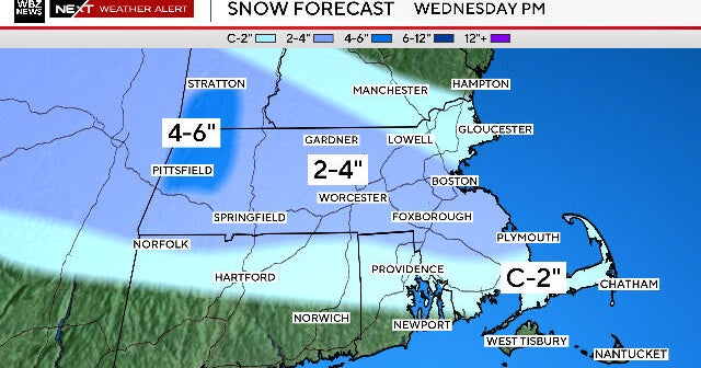
Before everything turns to rain and the snow melts, here is our current thinking on snow totals Tuesday morning:
Stay tuned to the WBZ weather team. We will keep you updated on any forecast changes.