No Excuses, Just An Explanation For Sunday-Monday Snow Totals
BOSTON (CBS) -- A very wise news director once told me "you are only as good as your last forecast." I can't remember the exact storm which preceded that Belichick-like comment, but we had nailed a very tough forecast. This was his way of saying, don't get carried away, things won't always go as planned. And boy was he right. The atmosphere will humble you real quick. It can happen at any time, during any storm. Even the all-time greats will tell you there are storm nightmares that still keep them up at night. WBZ legend, Barry Burbank has some harrowing tales of disasters amongst his many triumphs.
This winter has been very odd. Before this weekend, just about all of our snow for the season had fallen in about 15 hours on January 7th and January 29th. We have had several powerful coastal storms, most missed our region, obviously, the big one, the blizzard, was a direct hit and was forecast very well several days in advance. The praise from co-workers and viewers rolled in and all I could think of was "you are only as good as your last forecast." Twenty years later but still so true.
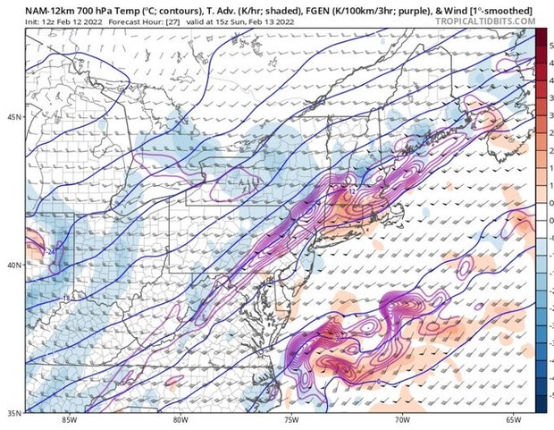
That brings us to the seemingly never-ending snow story which started early on Sunday and lasted more than 24 hours, causing over 100 schools to delay their start time Monday morning. You may remember forecasts from late last week calling for a coating to an inch near the Boston area and 1-3" over southeastern MA. Honestly, we even debated in the weather office if those numbers were too high. We hesitated to call it a storm and issue a weather alert given what the models were showing. Speaking of the models...obviously, we can't blame computers for our bad forecast but...All of our most trusted model guidance was showing something between a minor event and no event at all. The center of the actual storm was going to pass way too far east of New England for any major impact so, all we were really concerned with was a cold front and perhaps some ocean effect snow showers. I keep thinking back to a discussion Eric Fisher and I had late last week. We were looking at a somewhat unreliable model known as the NAM (I nicknamed it the SCAM years ago, that should give you a hint of how we feel about it) and it was showing an area of lift in the atmosphere, also known as "front-o-genesis" around 10,000 feet up (700 millibars). Normally we would see something like this and it would be a red flag for a more significant snow event than what we were forecasting...but it was the SCAM, it couldn't be trusted...welp, as they say, something about the sun shining on a dog's behind, or a blind squirrel gets a nut...it happened.
Frontogenesis map...those squiggly purple lines over MA was what we were debating over...
The storm tracked well to our east BUT that area of lift hundreds of miles away from the storm set up shop over southern New England and just sat and sat...and as Eric said on Twitter, we got "death by a thousand paper-cuts". The snow kept going and going and while during the daylight hours it didn't accumulate much, under the cover of darkness it did. And, it was fluffy enough to stack up to as much as 4-8" in a large portion of our area. Dave Epstein did update our snowfall forecast to 3-6" on Saturday, but even that wasn't enough for some areas.
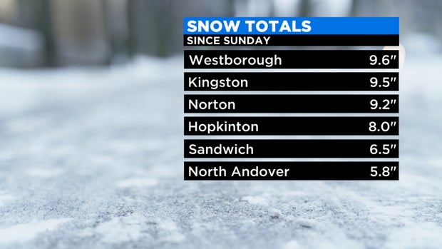
In the end, Boston ended up with 5.9", our third biggest snow event of the season. Many towns to the west and south ended up closer to 8 inches. One of the local "jackpot" measurements took place right at our local National Weather Service office in Norton (how fitting), they recorded just over 9 inches.
Not much else to say other than "It happens." No matter how much our models and technology have advanced, they are still far from perfect. The atmosphere is wild, complex and to a certain degree, still somewhat unpredictable.
Having said that, I will now give you a prediction for the rest of this week!
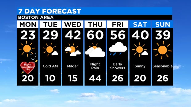
No more snow! We can say that with a fair amount of certainty. Temperatures remain frigid through early Wednesday and then a massive turnaround. We warm into the 40s on Wednesday and perhaps as high as 60 on Thursday. The current record on Thursday is 61 degrees in Boston. Wouldn't that be something if we set two high-temperature records in less than a week in the City with a snowstorm wedged in-between! Not to mention, we are also expecting some heavy rainfall Thursday night and perhaps even a few rumbles of thunder. Safe to say that all that fresh snow will, once again, be wiped off the map by the end of the week.