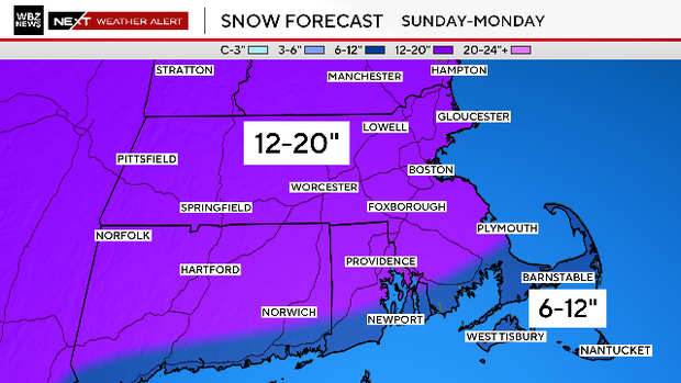
Snow piles up in double-digits across the Boston area. Maps show what's left for Massachusetts on Monday.
The Boston area is digging out from its biggest snowstorm in several years, as the latest forecasts predicted. Massachusetts got plenty of snow on Sunday. Unfortunately, this storm comes with more Monday.
We will be on the back side of the storm system on Monday, otherwise known as the "backlash." This is essentially the last gasp of the storm which will be moving away from New England.
There are a few major differences between the storm on day one and day two.
- The good news - the majority of the snow accumulation is done. About 80-90% has fallen.
- The winds will be veering towards the north, causing temperatures to drop across eastern Massachusetts once again.
- The snow will be more spotty and variable in coverage and intensity on Monday afternoon and evening.
In addition to the backlash area of snow, we will also be watching for some ocean-enhanced snow bands right along the coast. These bands are typically very localized but can be intense in bursts. Similar to the lake-effect snow in western New York, the variation in snow amounts can widely vary from town to town.
Snow timeline
By midday, the backlash will start to fill in and it should be snowing light to moderately across most of our area.
As the winds veer more northerly, temperatures will steadily drop across eastern Massachusetts.
There will be one final burst of snow between 5 p.m. and 9 p.m. across central and eastern Massachusetts.
If you are planning a final driveway cleanup, you will have to wait until this passes.
By 10 p.m., most of the snow has ended, with perhaps just a few final flakes over Cape Cod.
That will bring to an end a nearly 36-hour long snow event.
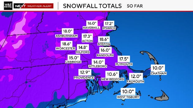
Snow totals
When all is said and done, we expect an additional 1-4" of snow accumulation on Monday.
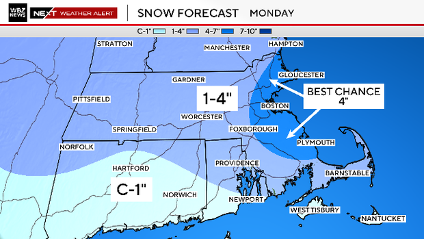
There may be some spot towns with slightly more than 4 inches thanks to those ocean-effect snow bands. The best chance would be coastal Essex County, Suffolk County (Boston area) and Plymouth County.
The day two snow may be just enough to place this storm in Boston's top 10 storms on record. The city needs to to reach 19.8", we are well on our way.

Fluff factor
Outside of the South Coast, Cape Cod and the Islands, the snow in this storm has been very light and fluffy. This is largely good news as it is much easier to move around.
This kind of snow also does not stick to tree limbs and power lines very well, so power outages are much less of a concern.
The one thing about snowfall in very cold temperatures is that it stacks up fast. You can easily get twice as much snow accumulation from a storm with temperatures in the teens as from one with temperatures near 32 degrees (both with the same actual melted liquid content).
The airmass behind this storm is quite cold and there will be very little melting next week. Temperatures are likely to stay below 32 degrees for the entire week.
Blizzard conditions?
We have very little concern about the wind with this storm. We will see northeasterly gusts between 20-40 mph right at the immediate coastline. This is much lower than our typical strong and destructive nor'easters. Can we call this a nor'easter? Technically yes, but the winds will only be a minor issue.
A reminder that in order to achieve "blizzard conditions" you need to have three consecutive hours with sustained winds or frequent gusts at or over 35 mph and visibility less than a quarter of a mile. That is not likely in the storm given the wind forecast. We may flirt with these types of conditions right at the coast at times, but sustaining them seems unlikely.
Boston weather radar
You can track the snowstorm with the CBS News Boston weather radar.

Stay tuned to WBZ-TV, WBZ.com and CBS News Boston for frequent updates before and during the storm. The WBZ NEXT Weather team has you covered.