1-To-3 Inches Of Steady, Heavy Rain In Forecast
BOSTON (CBS) - June is a month filled with outdoor activities from graduations to cookouts and Little League games. And normally other than a shower or thunderstorm here and there it goes off without a hitch
Check: Interactive Radar | Current Conditions | Weather Blogs
It is typically too early for any tropical systems and too late for any spring nor'easters - typically speaking that is.
I don't think you need me to tell you that this has not been your typical June.
In the first 12 days of this month, Boston has received nearly 7 inches of rain, about 2 months worth!
We are already approaching the top 10 wettest Junes on record. With a healthy dose of rain Thursday night we have a chance at cracking the top 5, and the month is not yet half over!
Thankfully, we had an unusually dry early spring, with only a little more than an inch of rain from April 1st through May 7th, otherwise we would be talking about major river flooding.
WHAT TO EXPECT
The storm that will be drenching us over the next 24 hours is not of tropical origins like Andrea earlier this month, but this time it will resemble more of a winter or early spring nor'easter in its track and origins.
This potent storm system will slide just to the south of New England tonight, tapping some Atlantic moisture and throwing back some gusty northeast winds as it passes.
Rain will overspread the area quickly and will be steady to heavy this afternoon and evening.
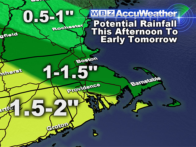
A general 1-3 inches of rainfall is expected, prompting yet another flood watch from the National Weather Service. We expect another round of small river and stream flooding, ponding on roadways and more urban/poor drainage flooding as well. The larger rivers should remain in their banks, but will continue to rise with each additional rain event, and certainly bear watching.
While rain will once again be the main threat with this storm, there are a few other concerns of note.
Winds will pick up overnight, especially at the coastline. Winds may gust as high as 45 mph over Cape Cod and the Islands and 30-40 mph along the South Coast. East facing beaches will see very high surf and dangerous rip currents through Saturday.
WHAT'S NEXT?
The rain will taper off early Friday morning, with just a brief shower possible during Friday afternoon and then we are home free for the weekend, just in time for Father's Day.
Highs this weekend will be near or just over 80 degrees with plenty of sunshine.
By the way, you may want to give Dad a hand mowing the lawn this weekend. With all the rain this week and sunshine this weekend, the lawns and gardens will be bursting to life once again!
You can follow Terry on Twitter at @TerryWBZ.


