Warming trend continues through the workweek across Maryland

Beautiful weekend weather has continued into the start of the new workweek. A gradual warming trend continues through the workweek, leading to a hot weekend across the Mid-Atlantic.
Tuesday begins with temperatures in the low to mid-50s in many neighborhoods. You may want a light jacket out the door in the morning. Sunshine sends temperatures into the mid-70s in many communities on Tuesday afternoon, with a breeze and low humidity.
Pleasant weather in Baltimore through mid-week
Temperatures remain cool in the mornings and warm in the afternoons through the middle of the workweek. A spotty shower, or two, cannot be ruled out through Tuesday afternoon. But, most will remain dry.
Southerly winds bring warmer air back to the mid-Atlantic as the workweek comes to an end.
Weather gets hot across Maryland this weekend
Afternoon temperatures will warm from around 80° on Wednesday, to around 90° on Friday afternoon. Both weekend afternoons will feature temperatures in the upper 80s and lower 90s.
Humidity creeps up just a bit later in the week. It may feel a few degrees hotter than what the thermometer says during the afternoons and early evenings.
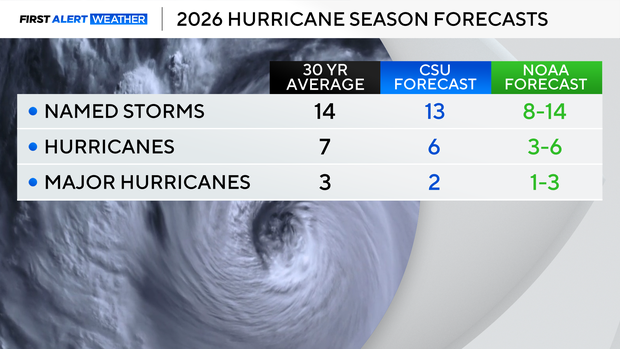
Hurricane season begins
Today, June 1, is the first day of the Atlantic Hurricane Season. Two forecasting centers - the National Oceanic and Atmospheric Administration (NOAA) and Colorado State University (CSU) - are forecasting below-normal activity for the 2026 season, primarily due to a rapidly developing strong El Nino.
A developing El Nino in the northeast Pacific Ocean typically leads to more wind shear across the Atlantic and 'sinking air'. Developing tropical system don't thrive in these conditions.