Rain and wind will impact Maryland as the weekend comes to a close

Following a beautiful start to the weekend, our next storm system will impact Maryland on Sunday. A period of windy, unsettled weather arrives as we close out the weekend and head into a new week.
Temperatures cool back through the 60s and into the 50s overnight across the Baltimore metro; coolest outside of the beltway and away from the bay. Temperatures will be warmer, but still pleasant, Sunday morning.
Gusty winds will develop across the Baltimore metro
Breezy winds will develop on Sunday as temperatures warm through the 60s and into the 70s during the afternoon. Sustained winds between 10 and 20 MPH are forecast during the afternoon and evening hours. Winds will easily gust between 25 and 35 MPH. A few gusts could approach 40 MPH, especially out on the bay.
Temperatures will peak in the low to mid-70s between 2 and 4 p.m. There will be much less sunshine across the state through the afternoon. The chance of rain increases from west, to east, during the evening hours.
Storms will move through central Maryland Sunday evening
Scattered showers are possible Sunday afternoon as clouds increase and winds pick up. The chance of rain and thunder increases after 5 p.m. and peaks between 9 p.m. and 3 a.m. Widespread rain and breezy winds are expected. A line of heavier rain and embedded thunderstorms will move through the Baltimore metro and eastern shore between 10 p.m. and 1 a.m.
A couple storms within the line could become severe and produce damaging wind gusts. Have, at least, one way to get severe weather alerts... just in case. The risk of a brief spin-up tornado is low. The risk of hail is very low. Brief heavy rain could cause water to pond in areas with poor drainage.
The positive - Maryland needs rain.
Cooler weather returns to Maryland next workweek
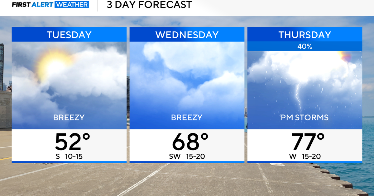
Damp weather lingers into the Monday morning commute, along with breezy winds. Temperatures will be in the 50s out the door early Monday. It'll remain the 60s Monday afternoon, with increasing sunshine and a breeze.
Another front approaches Tuesday, with just a slight chance of rain. Another round of much cooler weather blows into Maryland heading into mid-week. There will be multiple mornings with temperatures in the 30s in parts of central Maryland next week. Afternoons are forecast to remain cooler than average, with temperatures peaking in the 50s and 60s.
Have a great evening,
Cutter