Georgia winter storm: Ice warning remains in effect as refreezing roads and black ice impact Monday travel

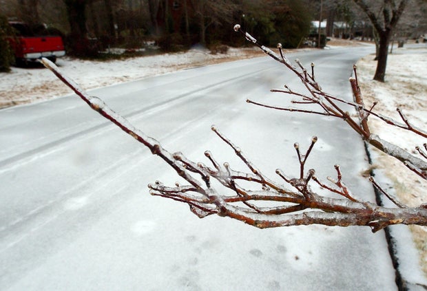
An ice storm warning remains in effect across much of north Georgia early Monday as dangerously cold temperatures refreeze wet roads, creating slick and hazardous travel conditions during the morning commute.
Ice Storm Warning remains in effect across north Georgia
The National Weather Service says the warning will stay in place until 10 a.m. for large portions of north and northeast Georgia, including the Atlanta metro area. While most of the moisture has moved out, freezing temperatures have caused leftover rain, slush and standing water to turn back into ice overnight.
Refreezing roads create hazardous morning travel conditions
CBS News meteorologist Troy Bridges said the biggest concern Monday morning is refreezing. Roads across north Georgia and metro Atlanta are still wet from earlier precipitation, and with temperatures well below freezing, ice has formed again, especially on bridges, overpasses, and untreated roads.
High temperatures will struggle to climb out of the 30s Monday, reaching about 33 degrees in metro Atlanta. Mountain communities will remain even colder, with highs only in the 20s. Gusty winds up to 30 mph will make it feel much colder, with wind chills in the single digits and teens across many areas.
Black ice and power outage risks continue
The National Weather Service warns that black ice is likely, particularly on secondary roads, back roads and mountain routes. Officials urge drivers to delay travel if possible. If travel is unavoidable, motorists are advised to drive slowly and with extreme caution.
Ice-related impacts are already being felt in parts of northeast Georgia and are expected to expand through the morning hours. The combination of lingering ice and strong winds increases the risk of falling tree limbs and damage to power lines, which could lead to additional power outages.
According to Georgia Power, outages have been reported all across the state, with residents in metro Atlanta, White, and Clayton counties feeling the impacts. As of Monday morning, hundreds of outages were reported in the Atlanta area and Clayton County, while nearly 50 communities in Cleveland and Helen in White County are without power.
Metro Atlanta school districts plan reopening
After most school districts in metro Atlanta and North Georgia either canceled class or moved to virtual learning on Monday, a few school districts have announced plans to return to normal for Tuesday.
Cobb County announced that all schools and offices will resume normal operations, including athletic events and extracurricular activities.
"After overnight monitoring of our schools and consultation with Cobb Emergency Services, conditions are expected to be safe for travel and school tomorrow," the district said.
Atlanta Public Schools will also resume operations on Tuesday, with buses running regular routes. Fulton County Schools will do the same.
Gwinnett County Public Schools will operate on a normal schedule on Tuesday. While schools and district offices will be open, we know there may still be patches of ice in some areas.
Fulton County Schools, including all schools and administrative offices, will be open and operating on normal schedules on Tuesday.
Tuesday will be a regular school/work day for DeKalb County Public Schools as the district resumes normal operations.
Henry County Schools will operate on a normal schedule on Tuesday. All schools and district offices will be open.
The leadership of Clayton County Public Schools, following a comprehensive and careful consideration of facility readiness and transportation availability, announced that the district will reopen for students and staff on Tuesday. The district will follow a regular schedule.
Ice accumulation totals across Georgia
Ice accumulation from this weekend's winter storm ranged from a light glaze to several tenths of an inch across parts of metro Atlanta, according to the National Weather Service. The highest totals were around 0.4 inches north of Milton and near Lake Lanier Island, while areas including Conyers and Cross Roads each recorded about 0.3 inches.
Dallas, Gainesville, Dunwoody, Brick Store, Monroe, Bethlehem, Tucker, Snellville, Lawrenceville, Cartersville and Acworth saw around a quarter-inch of ice. Roswell, Berkeley Lake, Holly Springs, Mountain Park, Rex and Austell received closer to two-tenths of an inch, with Alpharetta reporting just under two-tenths. Smaller amounts of roughly a tenth of an inch fell in Lilburn, Avondale Estates and Decatur, and only traces were reported in Douglasville, McDonough and Villa Rica.
Milton, GA — 0.4
Lake Lanier Island, GA — 0.4
Conyers, GA — 0.3
Cross Roads, GA — 0.3
Dallas, GA — 0.27
Gainesville, GA — 0.25
Dunwoody, GA — 0.25
Brick Store, GA — 0.25
Monroe, GA — 0.25
Bethlehem, GA — 0.25
Tucker, GA — 0.25
Snellville, GA — 0.25
Lawrenceville, GA — 0.25
Cartersville, GA — 0.25
Acworth, GA — 0.25
Holly Springs, GA — 0.2
Mountain Park, GA — 0.2
Roswell, GA — 0.2
Berkeley Lake, GA — 0.2
Rex, GA — 0.2
Austell, GA — 0.2
Alpharetta, GA — 0.19
Roswell (2 ENE), GA — 0.15
Lilburn, GA — 0.1
Avondale Estates, GA — 0.1
Decatur, GA — 0.1
Douglasville, GA — 0.05
McDonough, GA — 0.01
Villa Rica, GA — 0.01
Cold weather advisories extend into the week
Residents are also being urged to prepare for ongoing cold conditions. A Cold Weather Advisory remains in effect, and another advisory is expected Monday night into Tuesday morning. Feels-like temperatures will once again drop into the single digits and teens across north and central Georgia.
Very cold nighttime temperatures are expected to continue through at least Friday, raising concerns for vulnerable populations and areas already dealing with utility issues. Officials recommend protecting plants, pipes and animals, keeping flashlights available in case of power outages, and dressing in warm layers if spending time outdoors.


