Another Winter Storm With Snow And Ice Moving Through North Texas Wednesday Morning
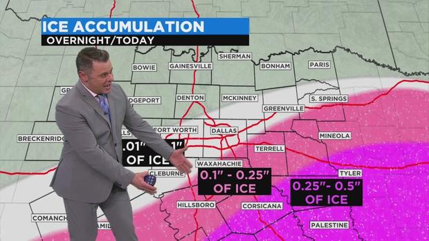
FORT WORTH (CBSDFW.COM) - Update 1:30AM - Snow and sleet has begun moving through the DFW Metroplex Wednesday morning. Areas south and east of DFW are expecting more ice than snow as the temperatures in the upper atmosphere become conducive to producing freezing rain and sleet. This could potentially have an impact on electrical infrastructure as trees and power lines could break under the pressure of up to a quarter inch of ice. Higher amounts of accumulation are possible further south and east of DFW.
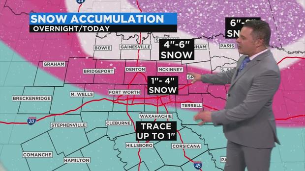
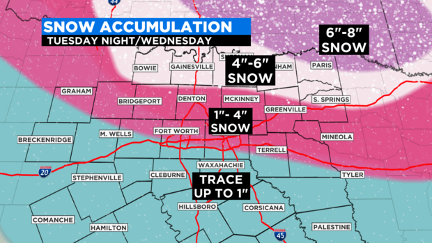
Much of DFW will see a 1 to 4 inches of snow possible, with the possibility of sleet and freezing rain south of I-20. Areas north of DFW could see as much as 6 inches of snow. It has been snowing most of the day along the Red River counties in Texas.
Previous Update - First off, we must discuss what happened Tuesday morning, Feb. 16.
In the wake of all the power outages across North Texas, we woke up to ONE OF THE COLDEST TEMPERATURES EVER RECORDED for the Metro area.
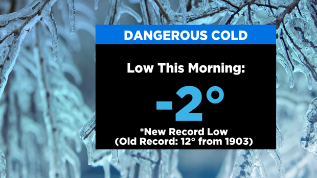
The -2 degrees ties for the second coldest morning ever and coldest in a generation.
Stunning.
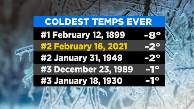
Ever since Sunday, every day has created record lows and records for coldest days.
We are under a WINTER STORM WARNING UNTIL 6AM THURSDAY.
We are already seeing snow fall in our western counties as of Tuesday afternoon.
Our next winter storm arrives this evening for the rest of North Texas.
Tuesday night, we are expecting snow, with the heaviest amounts along our Red River counties.
The Metroplex will have a wide range of snow amounts ranging from 1" in the southern edge to 4" in the northern edge.
Overnight and into Wednesday morning the snow is going to change over to a mix of sleet and snow, then freezing rain. It appears at this time that the dividing line is along I-20.
South of the I-20 corridor is where we are expecting the most ice.
Along our southern and southeastern counties this could be a damaging ice storm with amounts close to half an inch.
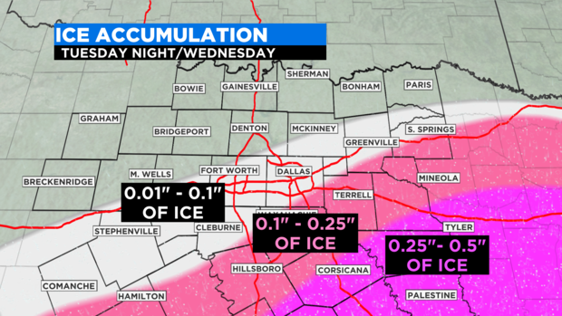
This would create power outages and make roads near impassible.
For the Metroplex we expecting to see icing over the snow. This will compact and freeze the snow and make for dangerous road conditions.
For this reason, we are expecting this winter storm to have a greater road impact than the one just two days ago.
The whole system causing this mess will lift out as we close the day on Wednesday.
Good news is just around the corner.
We are expecting dry and warmer weather for the weekend.


