Wind Chill Advisory In Effect In North Texas Through 9AM Friday, Another First Alert Weather Day
FORT WORTH (CBSDFW.COM) - A few snow flurries were still coming down Thursday night, Feb. 3, mainly west of I-35 near Breckenridge to Eastland.
They were very light flurries with no additional accumulations expected.
The bigger story is the ice and the cold.
The roads are slippery and the cold is brutal.
Temperatures are ranging from 17° to 25° and winds are out of the northwest at 10-15 mph. That means wind chill values are currently ranging from 3° to 14°.
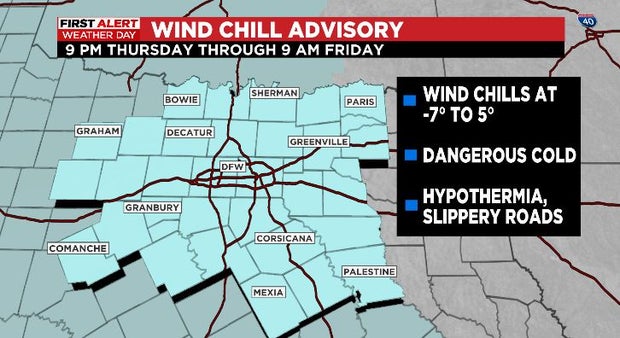
A Wind Chill Advisory went into effect at 9:00 p.m. Thursday and continues through 9:00 a.m. Friday.
Prolonged exposure to these conditions are dangerous as you run the risk of hypothermia.
And it's reinforcing the frozen roadways – we've been below freezing for 20 hours now and we're not expecting to be above freezing until Saturday afternoon.
Even staying below freezing, we should see some sunshine Friday.
So, on well-traveled roads we may see a bit of melting (like we did earlier today) but it'll all refreeze again after sunset, leaving tough driving conditions for Friday night into Saturday morning.
We are calling a First Alert Weather Day for Friday due to dangerous wind chill values/temperatures, and icy roads with the ongoing threat for dangerous travel.
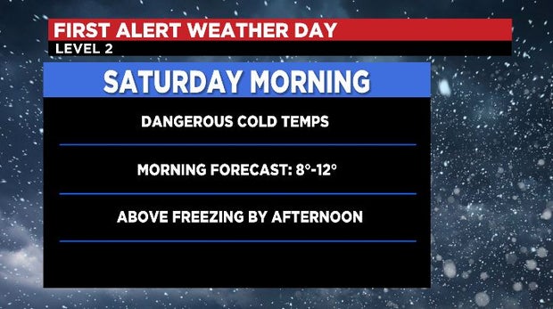
We've also issued a First Alert Weather Day for Saturday morning.
Skies will be clear and winds will be light late Friday into early Saturday – this leads to radiational cooling, and some of the coldest actual air temperatures so far.
The forecast low is 10° Saturday morning, prompting our call for a First Alert Weather Day, but it'll get to above freezing by Saturday afternoon.