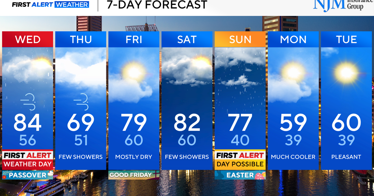
Warm Weather All Week...
WARM DAYS THE REST OF THE WEEK…
Temperatures will warm into the mid and upper 80s each and every day this week. We will start to see the winds pick up tomorrow, but it becomes windy on Thursday and Friday. This wind from the south will increase the humidity as we head into the weekend. Overnight lows will drop into the 50s tonight, but morning lows will warm into the mid 60s Thursday morning and then into the upper 60s for Friday and Saturday morning. Average high temperatures for this time of year are in the low 80s.
RAIN CHANCES NOT LOOKING GREAT THIS WEEKEND…
There is a large trough of low pressure taking up most of the western 1/3 of the United States. There are several disturbances embedded in the trough that will rotate thru the western US the next few days. The problem is that once these disturbances start to move east into the Central Plains they get shunted north thanks to a ridge of High Pressure that is sitting over the eastern 1/3 of the United States. So far this Ridge of High Pressure is winning out here in North Texas and that is meaning dry weather for us. As we head into the weekend it looks like the Ridge will still mostly win out. That means the best rain chances will be out in west Texas. This could turn out to be a healthy dose of rain for a couple of days starting Thursday thru the weekend for the Panhandle and West Texas. We will have a small chance of seeing a few showers and storms Saturday night into Sunday, but chances look much better to our west. So I will keep some small rain chances in the forecast for the weekend, but 20% to 30% at best.
TROPICAL DEVELOPMENT…
It is looking like the upper level pattern will be favorable for some Tropical Development in the Gulf of Mexico by the middle of next week. The favored area would be in the eastern Gulf. If there is a system that develops it would likely stay on the eastern side of the Gulf and not affect Texas. But it will be watched as we move toward next week.
Larry Mowry
CBS 11 Chief Meteorologist