Tropical Depression Edouard brings scattered rain, cooler temperatures to North Texas before Labor Day heat


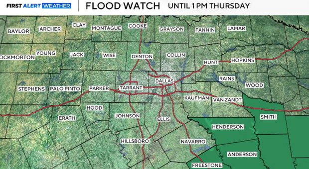
A flood watch is in effect for Henderson, Anderson and Freestone counties through Thursday afternoon. Localized flash flooding will be possible across our southeastern counties as the remnants of Edouard move slowly through the region.
The remnants of Edouard continue their slow northwestward movement Wednesday. The system is compact and moving slowly, which is creating a very sharp difference in rainfall over relatively short distances. We have already seen an extreme example of this closer to Houston, where some locations have received tremendous rainfall while others nearby have received considerably less.
We are not expecting rainfall totals of that magnitude across North Texas, but several inches of beneficial rain will be possible across our southeastern counties. The farther north and west you go, however, the lower the rain chances become. Unfortunately, some North Texans could still miss the rain entirely.
When will North Texas see rain?
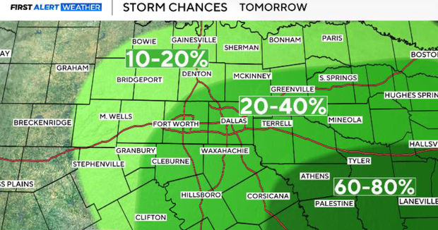
The greatest rain coverage remains southeast of the metroplex, while isolated showers and thunderstorms are possible farther north and west.
Around DFW, rain chances are generally only 10–30% Wednesday afternoon and evening. The lowest chances will be across our northwestern counties. Temperatures will also vary considerably because Edouard is such a compact system.
Where clouds and rain are more widespread, temperatures will be lower. Across much of North Texas, however, highs can still reach the upper 90s, with some western locations reaching the lower 100s.
Humidity is considerably higher, so even where actual temperatures are slightly lower, heat index values can still reach the triple digits. A storm or two on the outer edge of the tropical moisture could also produce a strong wind gust, but widespread severe weather is not expected.
Wednesday night is when the rain opportunity begins getting a little more interesting for the metroplex. The remnants of Edouard continue drifting northwest, allowing tropical moisture and some heavier rainfall to move closer to DFW.
Some of us could have a wet overnight period and Thursday morning commute, particularly across the southern and eastern portions of the metroplex. However, the heaviest and most persistent rainfall should remain southeast of DFW.
Showers are possible for DFW
Scattered showers and isolated thunderstorms remain possible Thursday, particularly south of I-20 and east of I-35. One of the biggest forecast challenges is exactly where the western edge of Edouard's rain sets up.
We expect a very tight rainfall gradient close to the southeastern side of the metroplex. That means one part of the area could receive beneficial rainfall while locations relatively nearby receive very little. Rain chances decrease quickly as you travel north and west.
More clouds should also help hold temperatures down somewhat Thursday, with much of the area along and east of I-35 in the low to mid-90s. Western North Texas remains hotter.
Will it rain this weekend in North Texas?
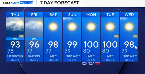
Edouard's remnants become increasingly disorganized Friday as drier air moves in. A few isolated showers or thunderstorms remain possible, but coverage drops considerably. As clouds and rain decrease, temperatures begin climbing again with widespread mid to upper 90s.
The break from the worst heat doesn't last long. Upper-level high pressure builds back toward the Southern Plains this weekend as Edouard completely dissipates.
DFW is forecast to be around 98° Saturday, 99° Sunday, and 100° Monday, and the humidity will make it feel even hotter. Afternoon heat index values across the region could reach roughly 103°–109° each day. Most of North Texas should also return to a predominantly dry pattern.
Looking ahead
The ridge remains in control into early next week, keeping temperatures in the upper 90s to lower 100s. So Edouard gives portions of North Texas a brief opportunity for beneficial rainfall and slightly lower temperatures, but it does not represent a lasting pattern change.