Severe Weather Blog: February 3
815pm - Severe weather threat is easing quite a bit over North Texas. Noisy storms in Denton & Collin counties still capable of producing dime hail and 40-50 mph gusts, just below severe limits. Also stronger storms affecting Fannin County. Barely any rain for Tarrant or Dallas County..just a bit of a pick up in the wind. SEVERE T'STORM WATCH continues until 2am for areas mainly along and north of I-20 and along and east of I35 E.
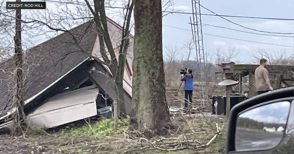
740pm - SEVERE T'STORM WARNING for Grayson & Fannin co's continue with threat for strong winds and golf ball hail.. Strong storms still in Denton County moving east/southeast but just below severe limits at this time.
710pm - TORNADO WATCH has been dropped and replaced with a SEVERE T'STORM WATCH until 2am for areas of North Texas generally along and north of I-20. Main threat is going to be from large hail up to golf ball size. We've already seen that in parts of Wise County earlier and also in Grayson County near Sherman. Storms should arrive in the Metroplex closer to 8-8:30pm...they will be noisy with lightning and thunder and gusty winds.
640pm - New SEVERE T'STORM WARNING for northern Denton County, mainly north of HWY 380. Storms still capable of strong winds and up to golf ball size hail. Storms moving east around 40mph. These storms forming along the cold front. Don't expect storms in the Metroplex until closer to 8pm
600pm - New SEVERE T'STORM WARNINGS for Cooke & Grayson counties, along with Montague and Wise counties...same issues...strong wind (60 mph) and possibly quarter size hail.
545pm - All warnings have been canceled at this time, but strong storms are still affecting Cooke County, approaching Gainesville. A line of storms is building back to the SW into Jack County. These storms still capable of producing 40-50 mph winds and dime to quarter size hail. Other strong storms in Erath County near Stephenville moving toward Glen Rose.
500pm - SEVERE T'STORM WARNING for northern Wise Co. until 545pm as well. Strongest part of storm between Alvord and Sunset along HWY 287. Up to 60 mph winds possible in western Cooke County as well approaching Muenster
445pm -Severe T'storm Warning for Cooke and Montague Co, TX until 545pm for quarter hail and winds to 60. St. Jo @ 455, #Gainesville at 520pm
430pm - Strong storms in Jack, Montague County continue to move slowly east. Hail has been main concern with up to quarter or ping pong size hail possible. No reports of hail so far. Still very quiet weather in metroplex. Storm chances for Dallas/Fort Worth will be highest between 7pm and 11pm. Isolated severe storms possible, but not widespread severe weather.
340pm -Severe T'storm Warning for Young Co and Jack Co, TX until 430pm. Ping pong size hail and 60mph winds possible. Jacksboro at 410pm
330pm - Severe Thunderstorm Warning continues for Montague County until 345pm. Storms continue to develop along the dryline and cold front to the west of DFW. Storm coverage remains rather limited. No new reports of hail out of Archer or Montague COunty but the radar is showing hail still capable of Quarter size. Elsewhere, quiet weather remains across Dallas and Fort Worth with just spotty showers. Tornado threat still exist in Watch area for at least next few hours, but overall threat is waning.
3pm - Only severe storms are located in Archer and Montague County. These have produced some hail up to half dollar size earlier in the hour. No reports of any damage. Elsewhere isolated showers continue to bubble up around Dallas County but nothing even close to being severe. Another area of rain is developing near Eastland SW of DFW. But the overall coverage of the rain is still pretty low at this hour.
Here is a look at where the dryline (black dashed line) and the cold front (blue line) is located at 3pm.
The cold front will overtake the dryline in the next few hours and push eastward. There will likely be a broken line of showers and thunderstorms along the front as it heads toward DFW after sundown. The timeframe for potential worst storms for metroplex would be between 6pm and 11pm.
2pm -
Strong thunderstorm continues to move in toward Clay County, just to the east of Wichita Falls. Other widely spaced storms are still developing over the far western areas of North Texas. This is going to be the favored area for more development between now and 4pm. Other, non-severe showers closer to the Metroplex and areas just to the northeast.
1:30
TORNADO WATCH for Denton, Parker, Palo Pinto, Cooke, Wise, Grayson, Jack, Young, Montague & Stephens counties until 8pm this evening. SEVERE T'STORM WARNING for Stephens County until 1:45p
Strong to severe thunderstorms will continue to develop in the areas west and northwest of the DFW area during the afternoon. This is where we've had a little sun to destabilize the atmosphere along a dryline, which is punching in from the west. Storms will have a greater threat of producing large hail up to golf balls, along with strong straight line winds. There is also a slight chance for tornadoes in some of the stronger storms as well. Keep it here on this blog for continuous updates through the afternoon.


