More storms in the forecast, then hotter weather returns
NORTH TEXAS (CBSNewsTexas.com) – We're tracking a few more storms in your First Alert Forecast before hotter weather moves in for the weekend.
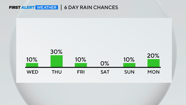
As we move through your Wednesday, a few isolated showers and storms are possible by afternoon and evening. The chance for rain is around 10% today.
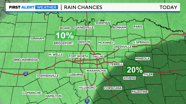
Communities east and southeast of the Metroplex will have a slightly higher chance of storms (20% chance). If storms develop, they'll be capable of producing gusty winds and small hail, along with frequent lightning.
Otherwise, we'll see mostly sunny skies. Highs will be in the upper 90s. Feels-like temperatures will be in the triple digits.
On Thursday, we'll have a slightly higher threat for showers and storms as a cold front nudges in from the north. In fact, a few showers are possible Thursday morning, but Thursday afternoon and evening will bring us our best chance for storms. Areas north and east of the Metroplex may see the highest threat for storms. But for now, area wide, our chance of rain Thursday is at 30%.
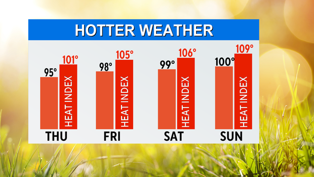
If any storms develop, they could be strong, capable of producing gusty winds, hail and frequent lightning. The overall threat for severe weather is low Thursday, but we'll keep an eye on the forecast. High temperatures will be in the mid 90s.
A spotty shower can't be ruled out on Friday. Most areas will be dry with highs in the upper 90s.
Then, get ready for the heat this weekend!
On Saturday, highs will be near 100°. Feels-like temperatures will be above 105°. We'll see mostly sunny skies. A stray shower can't be ruled out toward the Red River later in the day Saturday.
For Sunday, highs will be again near 100° with feels-like temperatures near 109° in a few spots. A stray shower or storm is possible toward the Red River.


