More Rain Chances this Week for North Texas
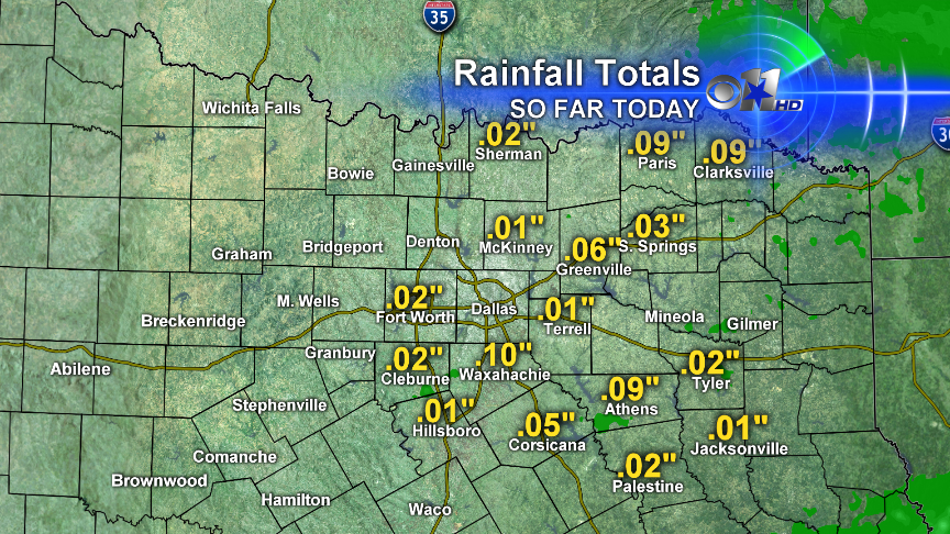
Spotty showers greeted our start to the day. Not much rain fell though. Most areas that did see rain saw well less that .10" of rain.
RAINFALL TOTALS FOR TODAY
FOG TONIGHT
As temperatures cool into the upper 40s and low 50s we will see patchy fog from across the area tomorrow morning.
TONIGHT'S LOWS
TOMORROW'S HIGHS
Mostly cloudy skies in the morning will give way to some sunshine. Temps in the mid to upper 60s with NE 5-10 mph
NEXT RAIN CHANCE
Several upper level disturbances to our west will impact North Texas this week. The first one is that small area of low pressure south of California. That will bring rain chances to us starting Wednesday into the day on Thursday. A stronger upper level disturbance is near Alaska. That one will bring us thunderstorm chances this weekend.
MID WEEK RAIN CHANCES
That first disturbance mentioned above will bring us rain chances starting on Wednesday. Here's a look at our rain chances.
WEDNESDAY
LATE WEDNESDAY NIGHT
THURSDAY
WEEKEND STORM CHANCES
Storms look likely this weekend with scattered storms on Saturday and higher coverage on Sunday. Still a little early to determine the severe threat, but it appears that Sunday will feature stronger thunderstorms than Saturday and some of those may be severe. But rainfall totals could exceed 1" to 2" in many areas as we will have slower moving thunderstorms and the chance for repeated rainfall over 36 hours.
NEEDED RAIN
We could use the rain. Below is a list showing the rainfall from April 2012 thru January 2013. You can see the deficit for each location and the percent of normal precipitation. Everyone is behind.


