Monday, April 18th Forecast Discussion
RECORD HEAT, STORMS AND EXTREME FIRE WEATHER…
The next 48 hours will feature a little bit of everything Spring has to offer here in North Texas. A dryline is situated to our west this afternoon with Red Flag Warnings up from Parker County to the west. This dryline will remain quiet tonight as the atmosphere is CAPPED. Ahead of the dryline here in Dallas and Fort Worth it is warm and muggy. Temps are in the low 90s in Fort Worth and upper 80s in Dallas. Heat Index values in Fort Worth are running in the mid 90s. But tomorrow, there will be an upper level disturbance that will likely uncap the atmosphere for some of us. Tonight we will see clouds increase after midnight and wake up to partly to mostly cloudy skies. Temperatures will only drop into the low 70s with south winds blowing 15 to 25 mph. Tomorrow as the upper level disturbance moves into the Central part of the Plains, the dryline will be pushed a little farther east in the afternoon. I expect the dryline to be draped over the metroplex in the afternoon and early evening tomorrow. This would mean very dry and hot weather for Fort Worth where temperatures could push into the upper 90s with relative humidity dropping well below 30%. In Dallas, highs will be in the low 90s with very muggy air and heat index values in the upper 90s. This dryline will likely be CAPPED thru most of the day to prevent storms until the evening. That is when the upper level energy gets a little closer to us and also when a cold front will start to cross the Red River. It appears that the best area for storms will be from the I-35E Corridor to the north and east tomorrow evening. This area is under the slight risk for severe weather.
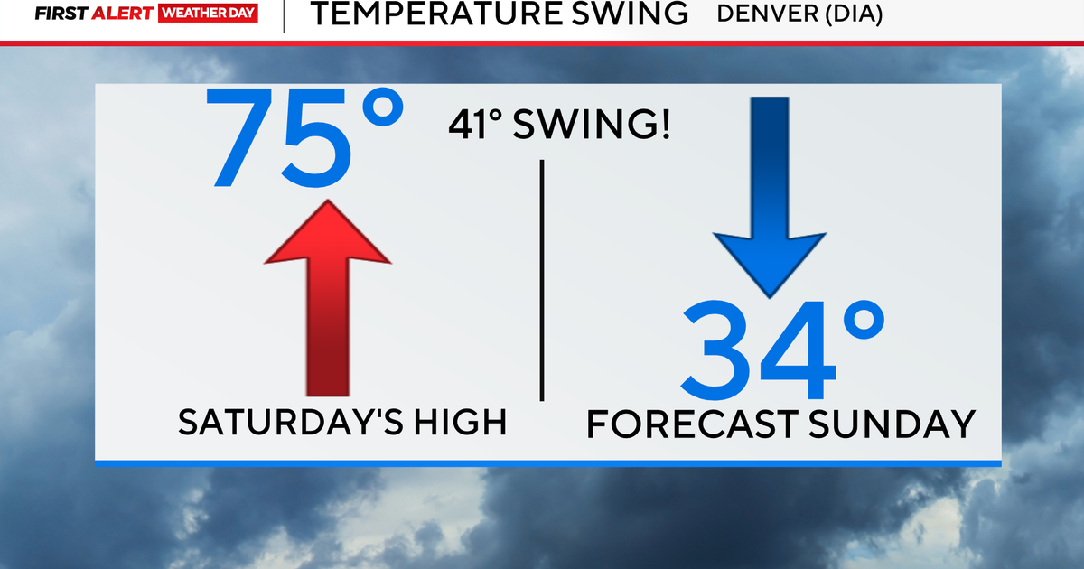
RECORD HIGHS TOMORROW…
The record high tomorrow at DFW is 93 degrees. I am forecasting a high of 94.
WEST OF THE DRYLINE…
As mentioned above from Fort Worth to the west, extreme fire weather conditions will develop. Winds will gusts to 45 mph with extremely dry air rushing in from the west off the high plains. Temperatures will warm into the mid to upper 90s with probably a few 100's in our western counties tomorrow.
EAST OF THE DRYLINE…
That warm and muggy air will be the area to watch for storms in the evening tomorrow. As the cold front pushed in tomorrow night storms will be likely in the evening and night.
WEDNESDAY COOLER WEATHER…
The cold front will sag southward Wednesday morning and we will be north of the cold front Wednesday. This mean cooler weather for Wednesday with highs near 80 degrees. Storms will likely develop along that front south of the DFW viewing area.
WEDNESDAY NIGHT STORMS RETURN…
That cold front will lift northward as a warm front Wednesday night and it appears there will be a decent chance of rain and thunderstorms Wednesday night into Thursday morning. There could be a few isolated hailers, but overall these should just be some general thunderstorms.
THURSDAY, FRIDAY, SATURDAY…
The dryline will be in our western counties each of these days and storms will have the chance to develop along that dryline and draw closer to the metroplex. These storms will have the possibility of being severe each day.
SUNDAY AND MONDAY…
A stronger upper level system will push into the area either Sunday or Monday and bring decent coverage to rain. The timing is a little uncertain as to which day will have the best rain chances.