Great Weather The Rest Of The Week
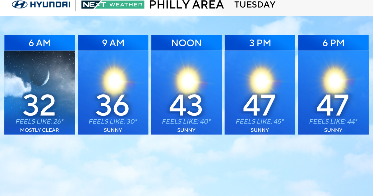
FORT WORTH (CBSDFW.COM) - Hard to believe that just 5 days ago we had a high temperatures of 36 degrees with sleet and snow on the ground. Today some areas topped out in the low 80s! At DFW we made it to 77 degrees.
A strong trough of low pressure has set up along the West Coast of the United States. This is bringing wet weather to the California Coast up to Seattle and snows in the mountains. A big trough like this on the west coast generally means high pressure building over the central part of the country. And that is exactly what is happening over Texas. This means warm weather for us with not much in the way of rain chances.
We are seeing strong south winds thanks to an area of low pressure developing along the lee side (east side) of the northern Rocky Mountains. This will track across the northern Plains the next few days and keep our winds rather breezy out of the south all week. This south wind is bringing Gulf Moisture our way. IN fact dew points have risen into the mid 50s. This means that overnight lows are very mild. Each night this week will see lows only in the mid to upper 50s.
This Gulf Moisture is rather shallow only going up into the sky about 3,000 feet. That is why we see low clouds develop in the morning and then thin our by mid to late morning. The moisture is too shallow to generate drizzle, but some patchy fog is possible in the low lying areas each morning. But with winds staying breezy dense fog will not occur.
Afternoon temperatures each day will top out in the mid to upper 70s thru Friday.
WEEKEND RAIN CHANCES…
It appears that moisture coming up from the Gulf will get a little deeper (meaning it will extend up from the surface thru about 6000 feet) this weekend. This will likely lead to some spotty showers on Saturday and Sunday. Coverage should not be terribly high and precip will be very light. Temperatures for the weekend will top out around 70 degrees each day with lows in the 50s.